The Horn of Africa has had years of drought, yet groundwater supplies are increasing – why?


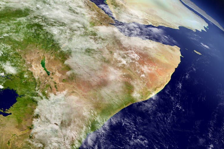
Harvepino / shutterstock

The Horn of Africa – which includes Somalia, Ethiopia, Kenya and some surrounding countries – has been hit by increasingly frequent and devastating droughts. Despite this, it seems the region has an increasing amount of groundwater. And this water could help support drought-stricken rural communities.

That’s the key finding from our new research, in which we discovered that while overall rainfall is decreasing, an increase in “high-intensity” rainfall has led to more water being stored deep underground. It’s a paradoxical finding, yet one that may help one of the world’s most vulnerable regions adapt to climate change.

In the Horn of Africa, rural communities live in a constant state of water scarcity punctuated by frequent periods of food insecurity. People there rely on the “long rains” between March and May and the “short rains” between October and December to support their lives and livelihoods.

As we write this, the region’s drylands are experiencing a fifth consecutive season of below-average rainfall. This has left 50 million people in acute food insecurity. The droughts have caused water shortages, livestock deaths, crop failures, conflict and even mental health challenges.

The drought is so severe that it is even affecting zebras, giraffes and other wildlife, as all surface waters are drying up and edible vegetation is becoming scarce. Worryingly, a sixth failed rainy season has already been predicted for March to May 2023.

Long rains down, short rains up

In a new paper we investigated changes in seasonal rainfall in the Horn of Africa over the past 30 years. We found the total rainfall within the “long rains” season is declining, perhaps related to the warming of a particular part of the Pacific Ocean. However, rainfall is increasing in the “short rains”. That’s largely due to a climate phenomenon known as the Indian Ocean Dipole, when a warmer-than-usual Indian Ocean produces higher rainfall in east Africa, similar to El Niño in the Pacific.

We then investigated what these rainfall trends mean for water stored below ground. Has it decreased in line with declining “long rains”, or risen due to the increasing “short rains”?
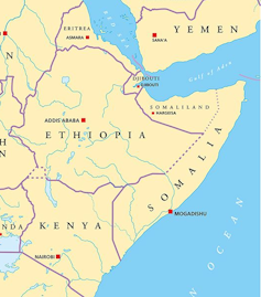
Map of East Africa
The Horn of Africa borders the Red Sea, the Gulf of Aden and the Indian Ocean.
Peter Hermes Furian / shutterstock

To do this we made use of a pair of satellites which orbit repeatedly and detect small changes in the Earth’s gravitational field that can be interpreted as changes in the mass of water storage. If there’s a significant increase in water storage underground, then the satellite will record a stronger gravity field at that location compared to the previous measurement, and vice versa. From this, the mass of water added or lost in that location can be determined.

Using these satellite-derived estimates, we found that water storage has been increasing in recent decades. The increase correlates with the increasing “short rains”, and has happened despite the “long rains” getting drier.

Given that the long rains deliver more seasonal rain than the short rains, we wanted to understand the paradoxical finding that underground water is increasing. A clue is given by examining how rainfall is converted into groundwater in drylands.

When rain is light and drizzly, much of the water that reaches the ground dampens the soil surface and soon evaporates back into the warm, dry atmosphere. To become groundwater, rainfall instead needs to be intense enough so that water will quickly infiltrate deep into the soil. This mostly happens when lots of rain falls at once and causes dry riverbeds to fill with water which can then leak into underground aquifers.
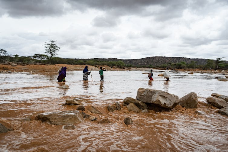
People stand in river, rainy sky.
Heavy rains fill a dry river bed in the Somali region of Ethiopia.
Stanley Dullea / shutterstock

These most intense rainfall events are increasing in the “short rains”, in line with the overall increase in total rain in that season. And despite a decrease in overall rainfall in the “long rains”, intense rainfall has remained consistently high over time. This means that both rainy seasons have enough intense rainfall to increase the amount of water stored underground.

Finally, we demonstrated that the increasing water storage in this region is not connected to any rise in soil moisture near the surface. It therefore represents “banked” water that resides deep below ground and likely contributes to a growing regional groundwater aquifer in this region.

Groundwater can help people adapt to climate change

While early warning networks and humanitarian organisations focus on the urgent impacts of drought, our new research points to a silver lining that may support long-term climate adaptation. Those rising groundwater supplies we have identified may potentially be exploited to support people in rural areas whose food and water are increasingly insecure.

But there are some caveats. First, we have not assessed the depth of the available groundwater across the region, but we suggest that the water table is shallow enough to be affected by seasonal rainfall. This means it may also be shallow enough to support new bore holes to extract it. Second, we do not know anything about the quality of the stored groundwater and whether it can be deemed suitable for drinking. Finally, we do not know exactly what will happen if the most extreme droughts of the past few seasons continue and both long and short rains fail, causing intense rainfall to decrease too.

Nevertheless, our findings point to the need for extensive groundwater surveys across the Horn of Africa drylands to ascertain whether this increasing water resource may be viable enough to offset the devastating droughts. Groundwater could potentially irrigate fields and provide drinking water for humans and livestock, as part of a strategy to help this vulnerable region adapt to the effects of climate change.The Conversation

————————

This blog was written by Cabot Institute for the Environment member Katerina Michaelides, Associate Professor, School of Geographical Sciences, University of BristolMichael Singer, Professor in Physical Geography (Hydrology and Geomorphology), Cardiff University; and Markus Adloff, PostDoctoral Researcher, Earth System Modelling, Université de BerneThis article is republished from The Conversation under a Creative Commons license. Read the original article.

World Water Day: Water scarcity challenges under climate change in East African drylands

Climate change presents great challenges for dryland regions, especially in communities where socioeconomic livelihoods are tied to the consistency of seasonal rainfall. In the dryland regions of East Africa, drought is a major threat to rainfed agriculture and to drinking water supplies, and regional climate is projected to increase drought frequency and severity.

Since 2000 alone East Africa has been struck by 10 droughts, which generated three severe famines affecting millions of people in the region. Although there is often consensus about the growing regional threat posed by drought, there is a major disconnect between the climate science (meteorological drought) and assessments of usable water resources (hydrological drought) that support livelihoods.

Affected communities need straightforward answers to a practical set of questions: How will regional climate change affect soil moisture required to grow crops or the water table in wells that provide precious drinking water in a parched landscape? How will the water stores change season by season and over coming decades? Furthermore, what adaptation strategies are available to address this challenge?

Through a series of funded projects, we have been working at better understanding how climate and climate change translates into useable water in the ground in East African dryland regions, and how people use and access relevant information to make livelihood decisions towards adaptation. We have developed an interdisciplinary team comprised of dryland hydrologists, climatologists, hydrometeorologists, computer scientists, pastoralist experts, and social scientists (both in the UK and Kenya, Somalia and Ethiopia) to develop a holistic perspective on both the physical and social aspects of drought. We are developing new regional modelling tools that convert past and future rainfall trends into soil moisture and groundwater. These models will underpin a new mobile phone app that aims to deliver forecasts of crop yields and soil moisture to remote agro-pastoralists. Simultaneously we are working with drought-affected communities in Kenya and Ethiopia to better understand barriers and opportunities for improving resilience to climate change, information use, and feasible adaptation strategies.

We hope that through these research endeavours we can contribute to improved climate adaptation efforts in these dryland regions and to long-term societal resilience to climate change.

Read more about Katerina’s work.

———————————-
This blog is written by Dr Katerina Michaelides, Head of Dryland Research Group at the School of Geographical Sciences and Cabot Institute for the Environment, University of Bristol.

Katerina Michaelides

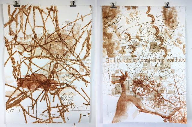
On the lively materiality of soil: A Somali Drylands artistic collaboration

© Sage Brice, 2018.

The WIDER-SOMA project was a cross-disciplinary and multi-institution research collaborative project headed by Dr Katerina Michaelides at the University of Bristol, investigating the effect of warfare on dryland environments in Somalia. I was excited to be invited to join the project in its later stages as artist in residence, supported by a small grant from the Cabot Innovation Fund. As an artist-geographer, my work explores the potential of drawing as a research methodology. I am interested in the unexpected things that happen in cross-disciplinary encounters, and the hazy zones where categories and definitions begin to break down.

The brief was to produce an artwork responding to the range of research specialisms involved in the project, to celebrate the ‘liveliness’ both of the collaborative research processes, and of the Somali Drylands themselves. We wanted to push back against the idea of drylands as ‘dead spaces’, drawing on the knowledge of people who engage closely with these landscapes in different ways, and appreciate their rich and complex ecologies.

© Sage Brice, 2018

I took as my starting point the lively materiality of the soil itself – its vibrant colours, varied textures, and characteristic dispositions offered a tangible way of engaging with the remarkable diversity within the research site. I was prompted by a comment from Dr Marianna Dudley, head of Bristol’s Centre for Environmental Humanities, and a key contributor to the project:

I love the way the soil gets loose and wanders. When we had the exhibitions in London and Bristol we found that the soil got everywhere; even though it was displayed in petri dishes, and when it hadn’t been moved – still the soil got out.

The messy, wandering, sideways processes were what interested me: how did ideas and inspiration cross between researchers in different disciplines, or between researchers and the materials they encountered? Could I, as an artist, enrich, facilitate, or make tangible those processes?

I decided to create two large drawings with the earth pigments, using layers of imagery relating to the different strands of research, and letting them overlap and disrupt each other on the surface of the paper. I was interested in everything – in my e-mail to participants I asked for

photographic imagery of microbial life, soil colour-charts, scribbles and sketches from the margins of your notebooks, graphs and maps, snapshots, postcards from sites you visited, random finds, slide presentations, logos and letterheads, gifts and mementos – anything and everything.

Thus I set out in a quest for incidental imagery – seeking out the visual traces of process, and looking to see where they might differ from the formalised imagery of presentations.

© Sage Brice, 2018.

I met and interviewed many of the researchers involved in the project, to hear about their specific strand of the research, and what about it had been most animating – but also to explain more clearly what I was after. To scientists used to presenting only clean, clear, and coherent findings, it seemed counterintuitive to ask for scribbles, notes, sketches, and first attempts. Many of the processes were more fully digitised or highly sanitised than I had imagined – in some cases there was little to work with visually, and I instead sourced imagery from internet searches, based on keywords the researchers helped to define.

© Sage Brice, 2018.

Once I had collected what I needed, I set about sifting through the material, sampling and experimenting with the soils themselves as pigments, feeling my way into an encounter with the various strands of material and practice. Working with the soils was a joy – as pigments they produced a richly clouded medium, with a range of textures and tones. I worked vertically with a water-based medium, allowing the pigments to dribble and disturb each other. Some were sandy or gritty and difficult to work – others sleek, fluid, and vibrant. I used each soil to draw imagery relating to its source of origin, and layered them over each other by colour to differentiate the strands of the work.

© Sage Brice, 2018.

The two drawings are arranged to echo and contrast with one another – a digitally plotted map against a hand-drawn one; the frenetic lines of cyanobacteria and a delicate web of roads, the sharp line of a mounted machine gun and a goat’s left horn. The drawings are large; seen close up the textures of the soils are on an equal standing with the content of the imagery.

The different threads of the project come together here in a messy collision – sometimes speaking to each other, sometimes disturbing each other. As a practice-based researcher with a special interest in cross-disciplinary collaboration, I am interested in how art processes can help to draw unexpected connections and enliven relations across conventional disciplinary divides. Coming in towards the end of a project, my role here was to look back at what had been done, to draw out and enliven an account of the collaborative process. I believe this way of working is important, and has a lot to offer for building connection, right from the start. Teasing out resonances between different disciplines of practice can help encourage people to work together and to step outside their comfort zones, in order to think afresh with new tools and approaches. I learned a lot about diverse kinds of research from interviewing the different participants – but what they consistently valued most from the process was what they learned from encountering and learning to understand each other’s work.

——————————-
This blog is written by Cabot Institute member Sage Brice, Artist In Residence with the support of the Cabot Institute Innovation Fund. Sage is an internationally exhibiting artist and an SWW DTP doctoral student in human geography at the University of Bristol. More on her work can be found at Sagebrice.com. Her doctoral research blog is cranecultures.wordpress.com.

All images © Sage Brice, 2018.

Sage Brice