#CabotNext10 Spotlight on Natural Hazards & Disaster Risk


Dr Ryerson Christie

In conversation with Dr Ryerson Christie, theme lead at the Cabot Institute

Why did you choose to become a theme leader at Cabot Institute?

Obviously with a decision such as this, there are numerous reasons informing our choices. However, there are three specific factors that were central to my agreeing to take this on.  First, and foremost, I am passionate about the theme.  Secondly, I have personally benefited from the work of the Cabot Institute, and as such I feel a responsibility to contribute back to the research institute.  Finally, while I have always seen value in interdisciplinarity, my own research on disasters has convinced me of the fundamental importance in increasing the ties between academic disciplines.  I should add as well that I would not have agreed to take on this role if I didn’t enjoy the people I am able to work with.

In your opinion, what is one of the biggest global challenges associated with your theme?

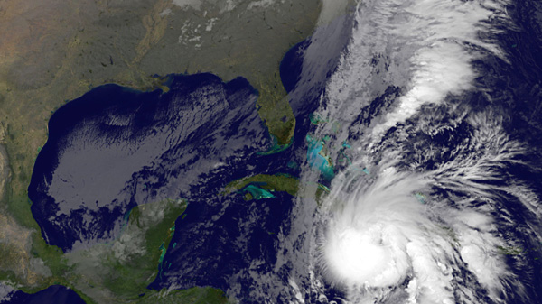
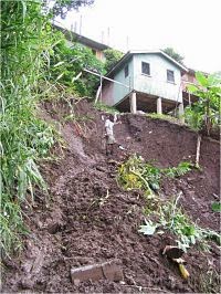
There are a multitude, and identifying one is difficult.  The nature of our area of focus, on natural hazards and disasters, means that we are dealing with the complex interface between geophysical processes, a changing climate, and societies.  Work across the working group relates to everything from seeking to better understand the science behind natural hazards, to how we can better design and maintain physical infrastructure, to how states and communities can reduce the potential impact of hazards.  However, if I have to pick one specific global challenge, it is how we can ensure that development can take place in a way that reduces vulnerabilities in a way that privileges the local voices in these paramount policy decisions.

As we are looking into the future, what longer term projects are there in your theme?

In a way that longer term projects that we will be undertaking in the years to come are no different from the ones in which we are currently engaged.  However, the impact of climate change is going to make the importance of these issues all the more acute.  So, we will be exploring in greater depth the intersectionality of vulnerabilities to disasters, expanding our geographic focus, and seeking further interdisciplinary approaches to these questions.

We have a number of ongoing research projects across Bristol, and I will note a few here:

Tomorrow’s Cities – The University of Bristol has a central role in this Global Challenges Research Fund (GCRF) Hub project, which is working with partners in Istanbul, Nairobi, Kathmandu, and Quito. The aim is to better understand disaster risk in the rapidly urbanising environment with the aim to ensure that future city development is resilient and addresses underlying drivers of disaster risk.

UK Flood Impacts project – This project is seeking to produce more accurate projections of the nature of UK flood risk which is crucial to ensure that policy decisions on mitigation, adaptation and development are fit for purpose.

Helping East Africa get Earthquake-Ready – focused on the East African Rift, this project is seeking to develop usable risk assessment tools to assist Malawi in disaster preparedness.  The project will also work with local authorities to co-produce planning guidelines to ensure development is resilient. A new statistical tool is being developed to help identify and help the most vulnerable sectors of society within disaster effected states.

Across the portfolio of projects in your theme, what type of institutions are you working with? (For example, governments, NGO’s)

The work that has been taking place within the hub has been extraordinary in the breadth of partners involved in the activities.  Crucially, the work is not only about targeting and helping states and communities, but it is motivated by a drive to empower communities and governments in alleviating disaster risk.  This means that the range of partners are actively involved in the entire life cycle of projects, from the identification of problems, co-designing research projects, the collection, interpretation and writing up of research, and the development and implementation of policy.  We actively work with local communities, social movements, and Non-Governmental Organizations (both local and international), all levels of Government, as well as regional and international organizations.

Please can you give some examples and state the relevant project

Tomorrow’s Cities is an exemplar here, where we are partners include community groups and formal NGOs in Quito, academics at FLACSO, the Instituto Geofisico, local and city level government representatives, and professional bodies representing engineers.  Without bringing all of these actors together we would not be able to fully appreciate the complexity of the problems, let alone develop and implement effective policies to reduce disaster risk.

What disciplines are currently represented within your theme?

We have been drawing on a broad range of disciplines, including Economics, Modern Languages, Sociology, Politics, Law, History, Civil Engineering, Geography, and the Earth Sciences.

In your opinion, why is it important to highlight interdisciplinary research both in general and here at Bristol?

The only way to redress the complex problems posed by natural hazards, is by bringing together the skills and expertise across the breadth of academia.  We can not bring about positive change by working in silos, and interdisciplinarity, while sometimes difficult, is fundamental.  We all come at the problems with different perspectives, tools and indeed language.  But we are all working for the same common ideal, of improving the lives of people, of reducing disaster risk, and doing so in a way that is empowering and sustainable.

Are there any projects which are currently underway in your theme which are interdisciplinary that you believe should be highlighted in this campaign?

All of our projects are interdisciplinary to one degree or another.  To highlight one in this respect is very difficult.  I suppose, if pushed, I would point to the work of the Tomorrow’s Cities team.  I would also like to highlight a previous project, BRACE, which was innovative in its integration of history, seismology, education, and engineering in a focused project seeking to increase resilience to Earthquakes in Bhutan.

Is there anything else you would like to mention about your theme, interdisciplinary research and working as part of Cabot Institute?

As with other working groups, our activities crosscut the breadth of Cabot and drawing lines between this working group and others is exceptionally difficult.  Cabot has been a fantastic catalyst to our work, and it is likely that little of these endeavours would have been possible without the support of the research institute.

For more information, visit Natural Hazards and Disaster Risk.

Tackling urban landslides in an uncertain future

One of the challenges of the 21st century is how to reconcile global urban growth with the prevention and mitigation of environmental disasters, such as those caused by landslides. Every year 300 million people are exposed to landslides worldwide, with over 4,000 fatalities, 250,000 of people affected, and billions of US dollars of economic damage. However, impacts might be worse in the future for two main reasons. First, severe precipitations might become more frequent under climate change, causing more rainfall-triggered landslides. Second, growing urban population will lead more people to live in areas exposed to landslides globally, and in particular in developing countries where low-income dwellers are starting to overcrowd landslide-prone areas such as steep slopes. With more hurricanes to come and more people at risk, understanding where and when landslides might occur is becoming increasingly crucial.

Current predictions are too uncertain to support decisions

One method to predict landslides in the future is to look at landslides in the past. The analysis of historical records allows the identification of those hillslopes that have failed in the past. Currently stable hillslopes where similar conditions exist (for example, similar slope gradients) are ‘tagged’ with high landslide probability. These areas might be then excluded for construction development or might be the first to be alerted when a severe precipitation is expected.

This approach to landslide prediction is, however, often insufficient. Landslides and rainfall records as well as data on hillslope properties are often affected by large errors or unavailable in sufficient detail. In addition, what happened in the past might not be representative of what may happen in the future, making historical records less useful for long-term projections. Climate and socio-economic models can be used to build scenarios of how rainfall patters and cities might look like in the future. Unfortunately, these scenarios can vary significantly because they depend on highly uncertain factors such as future carbon emissions. As a result, landslide estimates can also be very different and sometimes even contradictory – some predicting an increase and others a decrease in landslides occurrence – undermining their practical use for risk management.

From ‘predict then act’ to ‘act now with low regrets’

Instead of trying to predict how climate and urban expansion will evolve in the future, I used a different approach centred on decision making. I ask the question: how much climate and/or urban expansion needs to change before landslide hazard significantly increases?

The scientific method behind my analysis (Bozzolan et al. 2020, NHESS) first generates thousands of synthetic but realistic hillslopes representations of the study area. Then, it imposes hypothetical scenarios of increasing rainfall severities and urban expansion, also considering different construction features that could affect slope stability (for example, the presence or not of adequate slope drainage such as roof gutters on houses).

Finally, it uses a computer model to assess the stability of these virtual hillslopes, generating a new synthetic library of landslide records. By exploring the library is now possible to identify those combinations of rainfall and urban development conditions (e.g., with or without roof gutters) for which hillslopes are most likely to fail. ‘Low-regret’ mitigation actions will be those that perform well across scenarios and therefore should be prioritised even if future rainfall and urban predictions remain unknown.

A practical tool for decision makers

This new method which explores many ‘what if’ scenarios is a useful tool for decision makers in landslide risk management and reduction. For example, figure 1 shows how a map of landslide probability in Saint Lucia (Eastern Caribbean) might look like if the severity of a destructive rainstorm such as the 2010 Hurricane Tomas were to increase under climate change or if unregulated housing expanded on slopes susceptible to failure. The analysis also shows that when both scenarios are included landslide probability disproportionally increases, revealing that ‘the whole is greater than the sum of its parts’. This information could be used to assess the risk and damages associated with each scenario and to identify low-regret nation-wide risk reduction and risk transfer strategies.

Figure 1: Maps of landslide probability in Saint Lucia under different ‘what if’ scenarios. The percentage (+%) indicates the increase of areas with high landslide probability.

The same method can also be applied to quantify the cost-benefit ratio of different landslide mitigation options, such as improving urban drainage or tree planting at the community/household scale. In Freetown (Sierra Leone), for example, I collaborated with the engineering firm Arup to identify those landslide hazard mitigation actions that would lead to the largest reduction in landslide probability for certain locations or types of slopes, and should thus be prioritised. The information generated through this analysis not only provides evidence to governments and investors for informing urban planning, but it might also encourage landslide probability from low to high micro-insurance in disaster prevention, where insurers offer lower premiums to reward risk-reducing behaviours.

—————————–

This blog is written by Cabot Institute for the Environment member, Dr Elisa Bozzolan from the School of Civil Engineering at the University of Bristol.

Pearls of wisdom: The importance of knowledge exchange when facing environmental uncertainty

Dame Pearlette Louisy at the Living
at the Sharp End of Environmental
Uncertainty Conference, Bristol, 17
July 2014. Image credit: Amanda
Woodman-Hardy
On 17 July 2014, Dame Pearlette Louisy, Governor-General of Saint Lucia, came to the University of Bristol to give a keynote talk on the challenges and strategies on environmental uncertainty from Saint Lucia and the Caribbean.  Her visit marked the start of a Cabot Institute funded conference at the university, Living at the Sharp End of Environmental Uncertainty, where members of Small Island States (SIS) came together with academics and stakeholders to thrash out the problems facing SIS in a world of global environmental uncertainty.  This blog post captures some of the key points from Dame Pearlette’s talk.

Defining environmental uncertainty

 
Defining ‘environmental uncertainty’ is a tricky prospect.  What does the term actually mean?  It’s embedded into the Cabot Institute’s strapline of ‘Living with environmental uncertainty’ but it can be hard to define.  Dame Pearlette felt there were two principle components to ‘environmental uncertainty’ – a lack of knowledge and a lack of knowledge about how an environmental system will change in the future. 

Environmental challenges in the Caribbean

 
Hurricane Tomas, 2010. Image credit: Ryder Busby
The challenges facing the Caribbean are strongly based around environmental uncertainty.  It is an area highly prone to devastating natural disasters like hurricanes, earthquakes, landslides and volcanoes.   Being a small geographical area its vulnerability is increased especially as its dependence on tourism and agriculture for income can ruin its resilience by the occurrence of one natural event.  The limited capacity to develop, coupled with limited human resources and a fragile ecosystem means that the Caribbean’s ability to implement disaster risk reduction is relatively low.
One of the key things that stood out for me in Dame Pearlette’s talk was that the locals are noticing the effects of climate change already.  A little rhyme they use about the hurricance season goes like this:

June – Too Soon
July – Standby
August – You must
September – Remember

October – It’s all over

What is shocking is that hurricane season now lasts six months (June to November) leaving communities on tenterhooks for half of the year.  Comparing this to the old rhyme, it is clear to see that this is a much longer season than it used to be.
Sadly communities in the Caribbean are particularly vulnerable to all sorts of environmental impact.  Those living on reclaimed land or at sea level are prone to flooding by high water tides.  Communities also rely heavily on coastal and marine resources leaving them vulnerable when these are damaged by environmental events.  There is also the problem of getting insured in the Caribbean.  The islands are classified as high risk which has led to very high insurance premiums for people who can ill afford them.  This has led to communities not redeveloping after disasters.

Disaster management in the Caribbean

 
Haiti after Hurricane Tomas had passed through.
Image credit: DVIDSHUB
Caribbean disaster management is difficult as the people who live there cannot manage disaster responses by themselves.  However there are fantastic organisations across the Caribbean who are key to managing risk and are helping to build a resilient and sustainable future:


Dame Pearlette was keen to point out that enhanced international cooperation is needed if we are to improve sustainable development in the Caribbean region.  

New approaches to Saint Lucia’s landslide problem

 
Saint Lucia is volcanic in origin and it has steep slopes. Most flat land there is situated in a narrow belt, which is where most settlement is located.  Hurricane Tomas hit Saint Lucia in 2010 and it had a large impact on the community and its financial health.  Two years later there was a landslide on the main arterial road Barre de L’Isle.  This cut the island in two and caused substantial damage to infrastructure, buildings, the East Coast Road, slopes and water catchments including the Roseau Dam which collected a lot of silt.  Saint Lucia are still trying to desilt the dam which is causing water shortage problems this year. 
It is particularly difficult to reforest slopes after landslides as all the soil is swept away leaving bare rock.  Landslide disaster risk is increasing and new approaches to designing and delivering landslide risk reduction measures on-the-ground are urgently needed.  In response to that challenge, researchers at the Cabot Institute developed a novel methodology, Management of slope stability in communities (Mossaic), the vision for which is to provide low cost, community-based solutions, such as low cost drains and other related measures to reduce landslide hazard.  
 
You can read more about how the Cabot Institute has been working with St Lucia on this poster and this powerpoint presentation

Strategies for the Saint Lucia government

 
Dame Pearlette outlined some key strategies that Saint Lucia is implementing to improve its resilience to natural hazards and environmental uncertainty including a climate change adaptation policy; a strategic programme for climate resilience; a special programme on adaptation to climate change; a pilot programme for climate resilience; and a national environmental education policy and strategy.
However there is one key challenge and that is of funding. Saint Lucia has debts and what is troubling is that it is now difficult to borrow because lenders are not sure of Saint Lucia’s ability to pay their loans back which means the country continues to depend on external assistance of NGOs.  Although not an ideal situation, there is interesting work being funded by NGOs.  One such NGO is UNDP who are working with communities to achieve environmental sustainability with emphasis on the poor to build capacity.

Education for sustainable development – the future of environmental management?

 
At the end of Dame Pearlette’s talk, she shared her thoughts on the best way forward.  She strongly felt  that Education for Sustainable Development (ESD) is the best way to bring about environmental change.  Even though no Caribbean policy for ESD exists, there are many groups trying to embed ESD into their institutes of learning.  Dame Pearlette said that knowledge management is the management of an organisation’s knowledge assets for the purpose of creating value.  The key principle of uncertainty is about lack of knowledge.   Therefore knowledge creation and knowledge sharing is paramount for managing sustainability and thus it is the individual or country’s responsibility to ensure it keeps learning to reduce its environmental uncertainty.
Here at the University of Bristol, we also believe that ESD is a worthwhile ambition to embed sustainable development into our own curriculum. At the Cabot Institute we have appointed an intern to undertake a Community Based Learning project to place environmental postgraduate students with organisations in the local community.  By embedding our environmental knowledge and sharing it with our communities, we can help build a more sustainable world and more resilient communities to what seems to be a growing plight of environmental uncertainty.
 
This blog is by Amanda Woodman-Hardy (@Enviro_Mand), Cabot Institute, University of Bristol.
 
Amanda
Woodman-Hardy