New flood maps show US damage rising 26% in next 30 years due to climate change alone, and the inequity is stark


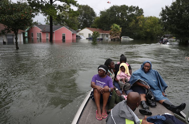
Coastal cities like Port Arthur, Texas, are at increasing risk from flooding during storms.
Joe Raedle/Getty Images

Climate change is raising flood risks in neighborhoods across the U.S. much faster than many people realize. Over the next three decades, the cost of flood damage is on pace to rise 26% due to climate change alone, an analysis of our new flood risk maps shows.

That’s only part of the risk. Despite recent devastating floods, people are still building in high-risk areas. With population growth factored in, we found the increase in U.S. flood losses will be four times higher than the climate-only effect.

Our team develops cutting-edge flood risk maps that incorporate climate change. It’s the data that drives local risk estimates you’re likely to see on real estate websites.

In the new analysis, published Jan. 31, 2022, we estimated where flood risk is rising fastest and who is in harm’s way. The results show the high costs of flooding and lay bare the inequities of who has to endure America’s crippling flood problem. They also show the importance of altering development patterns now.

The role of climate change

Flooding is the most frequent and costliest natural disaster in the United States, and its costs are projected to rise as the climate warms. Decades of measurements, computer models and basic physics all point to increasing precipitation and sea level rise.

As the atmosphere warms, it holds about 7% more moisture for every degree Celsius that the temperature rises, meaning more moisture is available to fall as rain, potentially raising the risk of inland flooding. A warmer climate also leads to rising sea levels and higher storm surges as land ice melts and warming ocean water expands.

Yet, translating that understanding into the detailed impact of future flooding has been beyond the grasp of existing flood mapping approaches.
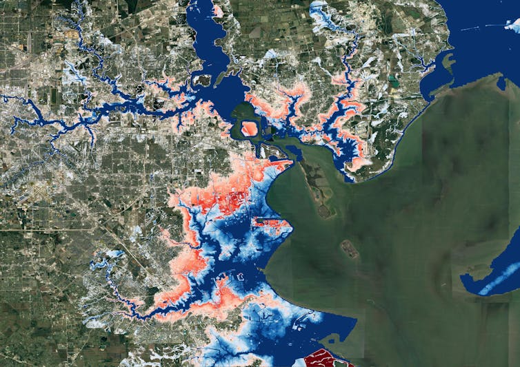
A map of Houston showing flooding extending much farther inland.
A map of Houston shows flood risk changing over the next 30 years. Blue areas are today’s 100-year flood-risk zones. The red areas reflect the same zones in 2050.
Wing et al., 2022

Previous efforts to link climate change to flood models offered only a broad view of the threat and didn’t zoom in close enough to provide reliable measures of local risk, although they could illustrate the general direction of change. Most local flood maps, such as those produced by the Federal Emergency Management Agency, have a different problem: They’re based on historical changes rather than incorporating the risks ahead, and the government is slow to update them.

Our maps account for flooding from rivers, rainfall and the oceans – both now and into the future – across the entire contiguous United States. They are produced at scales that show street-by-street impacts, and unlike FEMA maps, they cover floods of many different sizes, from nuisance flooding that may occur every few years to once-in-a-millennium disasters.

While hazard maps only show where floods might occur, our new risk analysis combines that with data on the U.S. building stock to understand the damage that occurs when floodwaters collide with homes and businesses. It’s the first validated analysis of climate-driven flood risk for the U.S.

The inequity of America’s flood problem

We estimated that the annual cost of flooding today is over US$32 billion nationwide, with an outsized burden on communities in Appalachia, the Gulf Coast and the Northwest.

When we looked at demographics, we found that today’s flood risk is predominantly concentrated in white, impoverished communities. Many of these are in low-lying areas directly on the coasts or Appalachian valleys at risk from heavy rainfall.

But the increase in risk as rising oceans reach farther inland during storms and high tides over the next 30 years falls disproportionately on communities with large African American populations on the Atlantic and Gulf coasts. Urban and rural areas from Texas to Florida to Virginia contain predominantly Black communities projected to see at least a 20% increase in flood risk over the next 30 years.

Historically, poorer communities haven’t seen as much investment in flood adaptation or infrastructure, leaving them more exposed. The new data, reflecting the cost of damage, contradicts a common misconception that flood risk exacerbated by sea level rise is concentrated in whiter, wealthier areas.
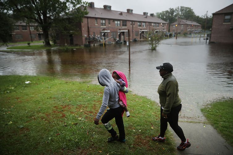
A woman carries a child past an area where flood water surrounds low-rise apartment buildings.
Hurricane Florence’s storm surge and extreme rainfall flooded towns on North Carolina’s Neuse River many miles inland from the ocean in 2018.
Chip Somodevilla/Getty Images

Our findings raise policy questions about disaster recovery. Prior research has found that these groups recover less quickly than more privileged residents and that disasters can further exacerbate existing inequities. Current federal disaster aid disproportionately helps wealthier residents. Without financial safety nets, disasters can be tipping points into financial stress or deeper poverty.

Population growth is a major driver of flood risk

Another important contributor to flood risk is the growing population.

As urban areas expand, people are building in riskier locations, including expanding into existing floodplains – areas that were already at risk of flooding, even in a stable climate. That’s making adapting to the rising climate risks even more difficult.
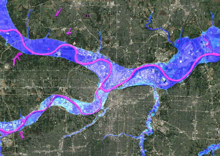
A satellite image of Kansas City showing flood risk overlaid along the rivers.
A Kansas City flood map shows developments in the 100-year flood zone.
Fathom

Hurricane Harvey made that risk painfully clear when its record rainfall sent two reservoirs spilling into neighborhoods, inundating homes that had been built in the reservoirs’ flood zones. That was in 2017, and communities in Houston are rebuilding in risky areas again.

We integrated into our model predictions how and where the increasing numbers of people will live in order to assess their future flood risk. The result: Future development patterns have a four times greater impact on 2050 flood risk than climate change alone.

On borrowed time

If these results seem alarming, consider that these are conservative estimates. We used a middle-of-the-road trajectory for atmospheric greenhouse gas concentrations, one in which global carbon emissions peak in the 2040s and then fall.

Importantly, much of this impact over the next three decades is already locked into the climate system. While cutting emissions now is crucial to slow the rate of sea level rise and reduce future flood risk, adaptation is required to protect against the losses we project to 2050.

[Over 140,000 readers rely on The Conversation’s newsletters to understand the world. Sign up today.]

If future development was directed outside of the riskiest areas, and new construction met higher standards for flood mitigation, some of these projected losses could be avoided. In previous research, we found that for a third of currently undeveloped U.S. floodplains it is cheaper to buy the land at today’s prices and preserve it for recreation and wildlife than develop it and pay for the inevitable flood damages later.

The results stress how critical land use and building codes are when it comes to adapting to climate change and managing future losses from increasing climate extremes. Protecting lives and property will mean moving existing populations out of harm’s way and stopping new construction in flood-risk areas.The Conversation

——————————-

This blog is written by Cabot Institute for the Environment members Dr Oliver Wing, Research Fellow, and Paul Bates, Professor of Hydrology, School of Geographical Sciences, University of Bristol; and Carolyn Kousky, Executive Director, Wharton Risk Center, University of Pennsylvania and Jeremy Porter, Professor of Quantitative Methods in the Social Sciences, City University of New York.

This article is republished from The Conversation under a Creative Commons license. Read the original article.

Welcome from the new Director

Left to right: Rich Pancost, Sir John Beddington, Paul Bates

I became the second Director of the Cabot Institute on the 28th of July, taking over from Paul Bates and planning to continue making Cabot one of the world’s premier environmental institutes. The past month has been rather exhilarating in terms of the breadth and quality of my interactions. My experiences have cemented my reasons for assuming this role – the Cabot Institute represents hundreds of brilliant people, working together and working with equally brilliant government, NGO and industry partners to better understand our environment, our relationship to it and the challenges of our co-dependent future. The central aspect of my job as Director is to continue to support those individuals and especially those collaborations.

My first month also confirmed that we have vital, illuminating and challenging ideas to share and we will all benefit from improved communications. Hence, this blog post and the many to follow it.  There are many buried treasures, both clever insights and mature wisdom, on the Cabot Blog, and I encourage new visitors to explore those past posts.  For example, see recent posts on Food Security by Boo Lewis and Energy Markets by Neeraj Oak.  As for me, I’ll be bringing in a combination of personal observations and insights arising from discussions with Cabot partners, as well as ideas emerging in my own discipline.

Penn State University

As a bit of an introduction, I grew up in on a dairy farm in Ohio, and attended Case Western Reserve University, where I dithered back and forth between majors in political science and astrophysics before realising my heart was in Geology…. life decisions are complicated for all of us. I obtained my PhD from Penn State University , using geochemical tools to study past climates, and then continued that work as a post-doctoral researcher at the Royal Netherlands Institute for Sea Research. And in 2000 I joined the Organic Geochemistry Unit  in the School of Chemistry here at Bristol.  Along the way, I played a fair bit of Ultimate (Frisbee ).

I examine organic compounds in a wide range of materials, from soils and plants to microbial mats to ancient rocks. Those organic compounds can be exceptionally well preserved for long periods of time, allowing us to investigate aspects of how the Earth’s biological and chemical systems interact on time scales from tens to millions of years. The topics of my research range from understanding the formation and fate of methane to reconstructing the climate history of the planet (especially during times when carbon dioxide levels and temperatures were higher than those of today). It requires working with a diverse group of people, including climate modellers, mathematicians, social scientists and petroleum geologists.  Those themes will become more prominent in this blog over the coming months, especially as I report back from a few conferences and around the release in late September of the Fifth Report from IPCC Working Group 1: The Physical Basis of Climate Change. But I will also be discussing Environmental Uncertainty and Decision Making: what it means, my personal perspectives on it, and why it is at the heart of the Cabot Institute’s mission.

Finally, this is meant to be an interactive forum.  Do use the comments section and do suggest future topics.  We especially welcome suggestions from our fellow Bristolians for potential visitors and events we could organise in our home town.

Cheers,
Rich

This blog was written by Professor Rich Pancost, Cabot Institute Director, University of Bristol

Rich Pancost

Brinkmanship, flood insurance and science

The “Statement of Principles” on flood insurance agreed by the UK Government and the Association of British Insurers as a temporary measure in the year 2000 is due to expire on 31st July 2013. At the heart of this document is an undertaking by insurers to continue to provide cover for domestic property and small business customers as long the Government continues to manage the risk adequately.

Specifically the agreement says that cover will be provided for properties built before 2009 either if the risk is low or there is a commitment by the Environment Agency to reduce it to low within 5 years. ‘Low’ risk is arbitrarily defined as a property having a less than 1.3% annual chance of flooding, of which there are believed to be ~200,000 in England and Wales. In other words properties need to be protected against the 1 in 75 year event.

Premiums can still vary with risk and the Statement makes no explicit provision for affordability, but the agreement does allow owners of some at risk properties to continue to obtain cover (and hence for buyers of these properties to obtain mortgages). An implicit assumption is that for properties built after 2009 the planning system has been operating effectively and has only allowed development in low risk zones.

Negotiations over a replacement were clearly going to the wire but today a Memorandum of Understanding was agreed between the ABI and the Government. This involves the setting up of a flood insurance pool known as ‘Flood Re’ for the ~200,000 ‘high risk’ properties. Premiums for the ‘high risk’ properties will be set based on council tax band. Flood Re will charge member firms an annual charge of £180 million which equates to a levy of £10.50 on annual household premiums.

This represents the estimated level of cross-subsidy that already exists between lower and high flood risk premiums. The scheme will be up and running by summer 2015 and in the meantime, ABI members will continue to meet their commitments to existing customers under the old Statement of Principles agreement.

Clearly the questions most commentators have fixated on are “who pays?” and “how much?”. However, as a flood scientist a far more interesting question is “how will we know?” and this applies as much to the existing Statement as to any new agreement. To put this another way: are we confident that we can determine to reasonable accuracy which properties are ‘at risk’? You might think this is typical academic hand wringing, but actually answering this question is, in my view, critical to running an effective flood insurance business.

For any given site the 1.3% annual chance flood will not have been observed and the Environment Agency and insurers use computer models that simulate flooding to calculate what such events look like. To use these you need to know how big the 1.3% annual probability flow is and to have a detailed 3D map of the terrain. The model then uses more or less complex variations on Newtonian physics to determine how this volume of water moves over the land surface.

At particular places such models can be great, but all predictions have error and because of uncertainties in both data and models this is certainly the case with flooding. How big can these errors be? Well, in a recent study we found the plausible range for the current 1% annual probability flow for the River Avon in Warwickshire to be between 310 and 425 m3s-1: enough to make a significant difference to the area predicted as inundated. Ok, this isn’t the 1.3% level exactly, but you get the idea. Models also get worse as you zoom out because to be computationally tractable at regional to national scales they have to simplify the representation of terrain and flow which introduces errors.

Irrespective of what the ABI and the Government do in the future, this situation doesn’t change. The question of how good national scale flood risk assessments need to be to confidently manage risk and set insurance premiums is still unanswered.

This blog is taken from WillisWire and written by Cabot Institute Director Professor Paul Bates, University of Bristol and Willis Research Network (WRN) Senior Academic. Edits by Tim Fewtrell, Chief Hydrologist at the WRN

Professor Paul Bates, Cabot Institute Director

Saving Species

Last night the Cabot Institute hosted a recording of the BBC Radio 4 programme Saving Species from the Great Hall here at the University of Bristol. The panel comprised the philosopher and activist Dr. Vandana Shiva, the Executive Director of the European Environment Agency Professor Jacequeline McGlade, Professor Aubery Manning of the University of Edinburgh and the Cabot Institute’s own Dr. Jon Bridle, who is a Senior Lecturer in Bristol’s School of Biological Sciences. As Cabot’s Director I was delighted to welcome such an eminent panel to the University and to run an event with the very dynamic Julian Hector from the BBC Natural History Unit which is based here in Bristol. The topic of the show was “Saving species: sustaining life” which the panel debated in response to audience questions. The idea was to explore the extent to which an increasing human population can be made compatible with efforts to preserve the natural world.

The thing that amazed me is how effortless every involved in the production, both the BBC crew and the major events people here at the University, made it look. I’ve rarely been to such a large event that has been pulled together so quickly and yet which seemed so serene. I wandered along a hour before the event to help with last minute panics and found myself very surplus to requirements. In the end I really could just stroll around meeting and greeting which was great. The other pleasing thing was that even on a wet and cold Monday evening in November the city of Bristol still turned out an audience of over 700 to watch the recording. I don’t know many other cities where this would happen and where the audience questions would be so perceptive and challenging.

I guess the crux of the programme was the extent to which one adopts an essentially neoMalthusian stance and argues that there are finite limits to population growth that can only met through population control, or whether one argues that it is not only how many people there are but how those people actually live that matters. The paradox seems to be that the things that lead populations to naturally restrict their growth (female education and emancipation, access to better healthcare and contraception, growing economic opportunities etc) have also historically led to significant increases in resource consumption: the development of aspirational middle classes in the developed world has significantly increased the total amount of the Earth’s resources that we use. How we construct a future development path for the planet that doesn’t lead to the resource depletion associated with the current western world economic model is a tough question to answer. There were some quite radically different views on this expressed by the panel, but instead of spoiling the plot I’ll let you listen to the broadcast to find out.

For me the event was excellent, and hopefully the audience enjoyed things too. If you’d like to listen to the programme it will be broadcast on Radio 4 at 8.00pm on Friday 23rd December.

Professor Paul Bates is Director of the Cabot Institute at the University of Bristol and undertakes research into flood risk and uncertainty.