Urban gardens are crucial food sources for pollinators – here’s what to plant for every season

A bumblebee visits a blooming honeysuckle plant.
Sidorova Mariya | Shutterstock

Pollinators are struggling to survive in the countryside, where flower-rich meadows, hedges and fields have been replaced by green monocultures, the result of modern industrialised farming. Yet an unlikely refuge could come in the form of city gardens.

Research has shown how the havens that urban gardeners create provide plentiful nectar, the energy-rich sugar solution that pollinators harvest from flowers to keep themselves flying.

In a city, flying insects like bees, butterflies and hoverflies, can flit from one garden to the next and by doing so ensure they find food whenever they need it.
These urban gardens produce some 85% of the nectar found in a city. Countryside nectar supplies, by contrast, have declined by one-third in Britain since the 1930s.

Our new research has found that this urban food supply for pollinators is also more diverse and continuous throughout the year than in farmland. Everyone with a garden, allotment or even a window box can create their own haven for pollinators. Here are tips on what to plant for each season.

Three people in wellington boots work on raised beds in a garden.
Community gardens, allotments, even window boxes can sustain pollinators throughout the year.
KOTOIMAGES | Shutterstock

What to plant in spring

The first queen bumblebees emerge from winter hibernation in February and March. They need food straight away.

At this time of year nectar-rich plants are vital energy sources for warming up cold flight muscles, with pollen providing the necessary protein for egg laying and larval growth. In early spring much of the countryside is still bleak and inhospitable.

Gardeners can help by planting borders of hellebore, Pulmonaria and grape hyacinth. Trees and shrubs such as willow, cherry and flowering currant are also fantastic for packing a lot of food into a small space.

A bee on a willow flower
Willow in bloom.
Ira Kalinicheva | Shutterstock

What to plant in summer

In late spring and early summer, pollinators have more food available – but there is also more competition for it. So it is crucial to ensure you have a diverse array of different flowering plants. This will guarantee there is attractive and accessible food to suit a wide range of insects and provide them with nutritionally balanced diets.

A great assortment of plants, including honeysuckle, Campanula and lavender, can provide floral resources in summer. Mowing the lawn a little less often will help too, giving the chance for important so-called weeds, such as clover and dandelion, to bloom.

Ivy in bloom with a red admiral.
Seepix | Shutterstock

What to plant in autumn

By late summer and autumn there are fewer species still flowering in gardens. A handful dominate the nectar supplies, particularly Fuchsia, Salvia and Crocosmia.

For many pollinators, however, these flowers are entirely useless. Their nectar is hidden away down a tube, only accessible to insects with long tongues, such as the garden bumblebee.

This means solitary bees and hoverflies may need to find other sources of food. The gardener can help by prioritising open and accessible flowers. Opt for species such as ivy, Sedum, Echinacea and oregano.

What to plant in winter

Few pollinators are still active in winter. Most species die off leaving the next generation behind as eggs, larvae or pupae.

But bumblebees and honeybees remain in flight, taking advantage of the warmer climate and winter flowers that cities can provide. By vibrating their wings, bumblebees can warm up to forage in temperatures barely exceeding freezing point, but they need a lot of energy-rich nectar to do so. If you want to attract bees into your garden during the winter some of the best options are Mahonia, sweet box, winter honeysuckle and the strawberry tree.

Yellow Mahonia on a frosty morning.
Mahonia on a frosty morning.
Sally Wallis | Shutterstock

Urban gardens are small and numerous, with hundreds or even thousands packed into a single square kilometre of a residential neighbourhood. Each gardener is different, with individual preferences of what to plant, how regularly to mow the lawn and even how to decide what constitutes a weed.

This results in an enormous variation from garden to garden in the quantity of nectar, the timing of its production and the types of flowers producing it. But there is always room for improvement. Some gardens provide pollinators with hundreds of times less nectar than others.

So keep yours well stocked with nectar and free from toxic pesticides. You’ll be amazed by the impact you can have.


This blog is written by Caboteers Nicholas Tew, PhD Candidate in Community Ecology, University of Bristol; Jane Memmott, Professor of Ecology, University of Bristol, and Katherine Baldock, Senior Lecturer in Ecology, Northumbria University, Newcastle

This article is republished from The Conversation under a Creative Commons license. Read the original article.

Drone Ecologies: Exploring the opportunities and risks of aerial monitoring for biodiversity conservation

Drones, also known as unmanned [sic] aerial vehicles (UAVs), are becoming an increasingly common technology within conservation, with uses ranging from mapping vegetation cover, to detecting poachers, to delineating community land claims. Drones are favoured as they’re cheaper and simpler than rival remote sensing technologies such as satellites, yet despite their benefits, they pose a number of issues regarding personal privacy rights and can be difficult to navigate in environments like dense forests. Moreover, as social scientists have previously highlighted, monitoring technologies such as drones have the potential to be used for covert surveillance in conservation areas as part of what they call ‘green securitisation’ (Kelly and Ybarra, 2016; Massé, 2018). To date, however, there has been limited discussion between drone practitioners and scientists across disciplines regarding what a drone can do, and how it is done.

This was the inspiration behind Drone Ecologies, an online workshop hosted by the University of Bristol on the 5th and 6th of July 2021. With over 60 participants representing various disciplines across the social and natural sciences, as well as experts from the arts, industry, and NGOs, the workshop aimed to create an open space for important interdisciplinary dialogues concerning the use of drones for conservation purposes. Through a series of panels, presentations, and breakout activities, we discussed the technical, operational, and analytical dimensions of drones, as well as the ethical, political, and sociocultural impacts of introducing drones and other monitoring technologies into conservation spaces. This essay offers an overview of the conversations that took place during the workshop, and we invite others to take part in these ongoing discussions.

Image 1: Calibrating drone sensors. Credit: Isla Myers-Smith

Our opening panel explored some of the operational benefits of drone technologies for environmental researchers. Drones can provide optical coverage over large areas with high spatial and temporal resolution, and have been successfully deployed to monitor various wildlife populations; assess changes in land cover; and map human-landscape interactions. However, with an increase in the technical capabilities of both drones and the sensors they carry, drones are becoming more than just airborne cameras. They can now be used to monitor other environmental components—e.g. noise, air pollution, and pollen levels—opening the door for new and diverse forms of data generation and analysis. Another emerging feature with huge potential for data collection is the integration of drones with other devices as part of the Internet of Things (IoT). Networks of coordinated drones that are able to share information and react in real-time could become instrumental in new anti-poaching efforts and for long-term, large-scale environmental monitoring.

Alongside a discussion of the advantages that drones provide for researchers and state agencies, much attention was given to the ways in which drones may be used to benefit local communities by, for example, monitoring forest fires within their concessions, or by demonstrating sustainable forest stewardship. Speakers such as Jaime Paneque-Gálvez and Nicolás Vargas-Ramírez from the National Autonomous University of Mexico showed how several community-based projects in South and Central America successfully utilised low-cost drones for participatory mapping processes. The researchers presented their experiences in teaching peasant and Indigenous communities in Mexico, Bolivia and Peru how to pilot and maintain drones, and how to incorporate drone-based imagery and orthomosaics into GIS products. These high-resolution, geo-referenced maps could then be used as evidence for territorial claims, or to expose environmental damage to forests and rivers. The use of drones granted the communities access to greater levels of spatial and temporal resolution with lower financial barriers, as well as greater degrees of inclusivity and autonomy over data collection when compared to satellite products.

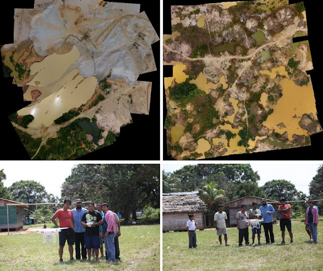
Image 2: Composite imagery of illegal gold mining and participants of a community drone workshop in Peru. Credit: Paneque-Gálvez et al. (2017)

Despite the logistical advantages of drones, there are still drawbacks regarding their use in environmental monitoring. Although they may reduce some environmental disturbances associated with monitoring—e.g. the cutting of tracks for transects—they also introduce new concerns, such as acoustic disturbance to wildlife under observation (and otherwise). However, some of the biggest concerns discussed during the second panel of the workshop were the negative impacts that drones may have on the communities living in and around the conservation areas being monitored. Trishant Simlai, a PhD candidate at the University of Cambridge, gave a plenary presentation showing how drones in India, along with other technologies used for conservation monitoring, form part of a deliberate system of surveillance and harassment of forest communities by the forestry department, exacerbating local inequalities along lines of class, caste, and gender, and producing ‘atmospheres’ of control. The second panel’s presentations also highlighted how, regardless of the operator’s intent, communities and individuals alter their behaviour when monitoring technologies are deployed by, for instance, avoiding areas that may have previously provided refuge and privacy.

During a group dialogue on green securitisation, Boise State University’s Libby Lunstrum posited several key observations on drones which formed the basis of ongoing conversations. Firstly, the militaristic origin of drone technologies raises concerns about the complicity of drone use with broader shifts towards militarised conservation and human rights violations. Secondly, unlike the cases presented by Paneque-Gálvez and Vargas-Ramírez, underlying power relations may mean that drone technologies are not always truly accessible for all community members. There are also epistemic concerns regarding the relationship between the disembodied and ‘objective’ knowledge purportedly produced by drones and the embodied and situated forms of knowledges produced by other, on-the-ground methods. Finally, there are a range of critical questions concerning the political economy of drone production: who is investing in these technologies? How do militarised actors participate in conservation, at times greenwashing harmful practices against local communities? How are drones complicit with these dynamics, and how do we reconcile that with their positive uses?

Given the above considerations, and the increasing use of drones for data collection, much of the final discussion at the workshop focused on the ethical implications of using drones within conservation. Drawing inspiration from Sandbrook et al.’s (2021) recent paper on the socially responsible use of conservation monitoring technology, we amended the guidelines set out in their paper to be specifically applicable to drones. Some key concerns included issues of proportionality—whether drones are always necessary tools for conservation practices—and the importance of recognising and foreseeing the potential for social implications in the first place. These concerns, we believe, are often obscured by the techno-optimism that surrounds drones, alongside a generally prevalent faith in technological solutions to conservation problems.

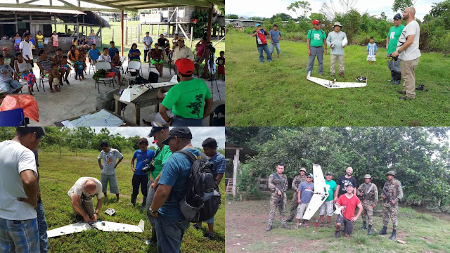
Image 3: Various groups involved in a community drone workshop in Panama. Credit: Paneque-Gálvez et al. (2017)

By the end of the workshop, it was clear that the use of drones for conservation purposes is a complex matter, and their use is subject to many conflicting ideas. Drones configure power relations in which social, political, and economic asymmetries and vulnerabilities can be exacerbated. However, drones can also be used for environmental justice purposes and can aid in the reduction of inequalities when their use is democratised and appropriate for local communities. The workshop also revealed some of the networks, assemblages, and ecosystems that drones inhabit, and that constitute power relations in which drones could play a role. It is important that these networks of relationships and interests that mobilise drones and other complementary technologies—e.g. satellite images—are made explicit, so that we can understand new configurations of power that are developing and identify those who benefit from the introduction of drones.

Additionally, the workshop also highlighted the relevance of multi- and interdisciplinary dialogues in understanding and developing the use of drones and other types of monitoring technologies for conservation purposes. We believe that it is important for these interdisciplinary networks to be established, and to continue exploring the complex impacts that drones have on environments, humans, and conservation practices. The interdisciplinarity approach simultaneously engages different disciplinary approaches and ethics, mitigating any blind spots within research and fully illuminating any potential damage or disturbances arising from drone use. This workshop marked an opening of these dialogues which we hope will continue within this emerging space, building towards the development of cross-disciplinary guidelines and policies for the ethical and responsible use of drones in conservation.

Recorded sessions from the workshop can be viewed at http://www.bristol.ac.uk/cabot/events/2021/drone-ecologies.html

References

Kelly AB and Ybarra M (2016) Introduction to themed issue: ‘Green security in protected areas’. Geoforum 69: 171–175. DOI: 10.1016/j.geoforum.2015.09.013.

Massé F (2018) Topographies of security and the multiple spatialities of (conservation) power: Verticality, surveillance, and space-time compression in the bush. Political Geography 67: 56–64. DOI: 10.1016/j.polgeo.2018.10.001.

Paneque-Gálvez J, Vargas-Ramírez N, Napoletano B, et al. (2017) Grassroots innovation using drones for Indigenous mapping and monitoring. Land 6(4): 86. DOI: 10.3390/land6040086.

Sandbrook C, Clark D, Toivonen T, et al. (2021) Principles for the socially responsible use of conservation monitoring technology and data. Conservation Science and Practice 3(5). DOI: 10.1111/csp2.374.

——————————-

This blog was written by Cabot Institute for the Environment members Ben Newport and Georgios Tzoumas; and Mónica Amador and Juan Felipe Riaño. It has been reposted with kind permission. View the original blog.

Energy landscapes and the generative power of place

Spring 2020 will be remembered for the global Covid-19 pandemic. While in Britain people  were ordered to stay at home in a national lockdown, the nation also experienced its longest run of coal-free energy generation since the Industrial Revolution – 68 days of coal-free power. This wasn’t unconnected: as the economy shrunk almost overnight some of the major industrial energy uses stopped; steady low usage meant that the ‘back-up’ coal-fired generators of the national grid weren’t needed. Nor was this fossil-free: oil, alongside nuclear and gas, continued to fuel power plants. But, more than ever before, our energy was produced by renewable sources, and on 26 August 2020, the National Grid recorded the highest every contribution by wind to the national electricity mix: 59.9%.

This shift out of fossil dependence is both a historic moment, and the product of historical processes. The technological and scientific work that underpins the development of efficient turbines has taken decades – and it is what I’ve written about in my article, ‘When’s a gale a gale? Understanding wind as an energetic force in mid-twentieth century Britain’, out now in Environmental History. I look at how interest in the wind as a potential energy source (by the British state, and state scientists), generated the need for knowledge about how wind worked. Turbine technology needs airspace to operate, but it also needs land – to ground the turbines in, to connect to the grid by – and people to install and operate the devices. And so when looking at energy landscapes, we really need to think beyond the technology and consider the people and places with which it interacts,  to understand how energy is produced and used.

Hauling wind measuring equipment up Costa Hill, Orkney. In E.H. Golding and A.H. Stodhart, ‘The selection and characteristics of wind-power sites’ (The Electrical Research Association, 1952). Met Office Archive.

This was certainly the case for understanding wind energy. In 1940s and 50s Britain, scientists surveyed the wind regime at a national scale for the first time. They relied on the help and cooperation of local people to do this. In the brief mentions of this assistance in the archival record, we gain insight into the importance of embodied, localised knowledge in scientific processes which can at first seem detached from the actual landscapes of study.

The surveys determined Orkney as the best place to situate a test turbine. Embodied knowledge, knowledge that is learnt from being in place and from place, is very tangible in accounts of a hurricane which hit Orkney in 1952, during the turbine tests. By looking at how the islanders made sense of a disastrous wind, and brought the turbine technology into their narratives of the storm, we learn that it is not only electricity generated by the development of renewable energy, but also new dimensions to place-based knowledge and identities.

Seeing beyond the technology to consider its interactions with environments and societies is something that the energy humanities considers as essential. I’ll be working on this subject from this perspective for some time to come, and would love to hear your thoughts on the article.

Costa Hill from the coast path. Photograph by Marianna Dudley, 2017.

——————————-

This blog has been reposted with kind permission from the Bristol Centre for Environmental Humanities. View the original blog. This blog was written by Cabot Institute for the Environment member Dr Marianna Dudley. You can follow Marianna on Twitter @DudleyMarianna.

Life after COVID: most people don’t want a return to normal – they want a fairer, more sustainable future

Jacob Lund/Shutterstock

We are in a crisis now – and omicron has made it harder to imagine the pandemic ending. But it will not last forever. When the COVID outbreak is over, what do we want the world to look like?

In the early stages of the pandemic – from March to July 2020 – a rapid return to normal was on everyone’s lips, reflecting the hope that the virus might be quickly brought under control. Since then, alternative slogans such as “build back better” have also become prominent, promising a brighter, more equitable, more sustainable future based on significant or even radical change.

Returning to how things were, or moving on to something new – these are very different desires. But which is it that people want? In our recent research, we aimed to find out.

Along with Keri Facer of the University of Bristol, we conducted two studies, one in the summer of 2020 and another a year later. In these, we presented participants – a representative sample of 400 people from the UK and 600 from the US – with four possible futures, sketched in the table below. We designed these based on possible outcomes of the pandemic published in early 2020 in The Atlantic and The Conversation.

We were concerned with two aspects of the future: whether it would involve a “return to normal” or a progressive move to “build back better”, and whether it would concentrate power in the hands of government or return power to individuals.

Four possible futures

Back to normal – strong government
“Collective safety”

    • We don’t want any big changes to how the world works.
    • We are happy for the government to keep its powers to keep us safe and get back on economic track.


Back to normal – individual autonomy
“For freedom”

  • We don’t want any big changes to how the world works; our priority is business as usual and safety.
  • We want to take back from governments the powers they have claimed to limit our movements and monitor our data and behaviour.
Progressive – strong government
“Fairer future”

  • What we want is for governments to take strong action to deal with economic unfairness and the problem of climate change.
  • We are happy for the government to keep its powers if it protects economic fairness, health and the environment.
Progressive – individual autonomy
“Grassroots leadership”

  • What we want is for communities, not governments, to work together to build a fair and environmentally friendly world.
  • We want to take back from governments the powers they have claimed to limit our movements and monitor our data and behaviour.

In both studies and in both countries, we found that people strongly preferred a progressive future over a return to normal. They also tended to prefer individual autonomy over strong government. On balance, across both experiments and both countries, the “grassroots leadership” proposal appeared to be most popular.

People’s political leanings affected preferences – those on the political right preferred a return to normal more than those on the left – yet intriguingly, strong opposition to a progressive future was quite limited, even among people on the right. This is encouraging because it suggests that opposition to “building back better” may be limited.

Our findings are consistent with other recent research, which suggests that even conservative voters want the environment to be at the heart of post-COVID economic reconstruction in the UK.

The misperceptions of the majority

This is what people wanted to happen – but how did they think things actually would end up? In both countries, participants felt that a return to normal was more likely than moving towards a progressive future. They also felt it was more likely that government would retain its power than return it to the people.

In other words, people thought they were unlikely to get the future they wanted. People want a progressive future but fear that they’ll get a return to normal with power vested in the government.

We also asked people to tell us what they thought others wanted. It turned out our participants thought that others wanted a return to normal much more than they actually did. This was observed in both the US and UK in both 2020 and 2021, though to varying extents.

This striking divergence between what people actually want, what they expect to get and what they think others want is what’s known as “pluralistic ignorance”.

This describes any situation where people who are in the majority think they are in the minority. Pluralistic ignorance can have problematic consequences because in the long run people often shift their attitudes towards what they perceive to be the prevailing norm. If people misperceive the norm, they may change their attitudes towards a minority opinion, rather than the minority adapting to the majority. This can be a problem if that minority opinion is a negative one – such as being opposed to vaccination, for example.

In our case, a consequence of pluralistic ignorance may be that a return to normal will become more acceptable in future, not because most people ever desired this outcome, but because they felt it was inevitable and that most others wanted it.

Two people talking on a bench
We think we know what other people think – but often we’re wrong.
dekazigzag/Shutterstock

Ultimately, this would mean that the actual preferences of the majority never find the political expression that, in a democracy, they deserve.

To counter pluralistic ignorance, we should therefore try to ensure that people know the public’s opinion. This is not merely a necessary countermeasure to pluralistic ignorance and its adverse consequences – people’s motivation also generally increases when they feel their preferences and goals are shared by others. Therefore, simply informing people that there’s a social consensus for a progressive future could be what unleashes the motivation needed to achieve it.The Conversation

——————————-

This blog is written by Caboteer Professor Stephan Lewandowsky, Chair of Cognitive Psychology, University of Bristol and Ullrich Ecker, Professor of Cognitive Psychology and Australian Research Council Future Fellow, The University of Western Australia

This article is republished from The Conversation under a Creative Commons license. Read the original article.

Wheel of Time is set thousands of years from now, yet it’s still burdened with today’s climate change

The epic fantasy series has been turned into a tv show on Amazon.
JAN THIJS/AMAZON STUDIOS

Wheel of Time, the 14-book epic fantasy now turned into an Amazon Prime TV series, is a medieval-style adventure set in the Third Age of the World of the Wheel. While not explicit in the storyline, notes from the late author suggest that the First Age was actually modern-day Earth, which ended with a dramatic event (perhaps even climate change). From these notes, we estimate the show takes place around 18,000 years from today.

For climate scientists like us, this poses an interesting question: would today’s climate change still be experienced in the World of the Wheel, even after all those centuries?

About a quarter of carbon dioxide emitted today will remain in the atmosphere even 18,000 years from now. According to biogeochemistry models, carbon dioxide levels could be as high as 1,100 parts per million (ppm) at that point. That’s compared with a present-day value of 415ppm. This very high value assumes that the Paris climate goals will be exceeded and that many natural stores of carbon will also be released into the atmosphere (melting permafrost, for instance).

But the high carbon dioxide concentrations do not necessarily mean a warmer climate. That’s because, over such a long period, slow changes in the orbit and tilt of the planet become more important. This is known as the Milankovitch Cycle and each cycle lasts for around 100,000 years. Given that we are currently at the peak of such a cycle, the planet will naturally cool over the next 50,000 years and this is why scientists were once worried about a new ice age.

But will this be enough to offset the warming from the remaining carbon dioxide in the atmosphere? The image below shows a version of the classic warming stripes, a ubiquitous symbol of the past 150 years of climate change, but instead applied over 1 million years:

Annotated stripes
Warming stripes of Earth (and the World of the Wheel) for a million years. Today’s climate crisis will disrupt the Milankovitch cycle and its effects will last for many thousands of years.
Authors modified from Dan Lunt et al, Author provided

You can clearly see the 100,000 year Milankovitch cycles. Anything red can be considered anthropogenic climate change, and the events of the Wheel of Time are well within this period. Even the descending Milankovitch cycle won’t be enough to counteract the increased warming from carbon dioxide, and so the inhabitants of the World of the Wheel would still experience elevated temperatures from a climate crisis that occurred 18,000 years ago.

Simulating the weather of the World

However, some of the weather changes from the still-elevated temperatures could be offset by other factors. Those 18,000 years aren’t very long from a geological perspective, so in normal circumstances the landmasses would not change significantly. However, in this fantasy future magical channelers “broke” the world at the end of the Second Age, creating several new supercontinents.

To find out how the climate would work in the World of the Wheel, we used an exoplanet model. This complex computer program uses fundamental principles of physics to simulate the weather patterns on the hypothetical future planet, once we had fed in its topography based on hand-drawn maps of the world, and carbon dioxide levels of 830ppm based on one of the high potential future carbon pathways.

According to our model, the World of the Wheel would be warm all over the surface, with temperatures over land never being cold enough for snow apart from on the mountains. No chance of a white Christmas in this future. Here the story and the science diverge, as at times snow is mentioned in the Wheel of Time. The long-term effects of climate change may have surpassed the imagination of its author, the late great Robert Jordan.

An animated map with arrows
A simulation focused on where The Wheel of Time events take place, showing surface winds (white arrows).
climatearchive.org, Author provided

The World of the Wheel would have stronger and wavier high-altitude jet streams than modern-day Earth. This is likely because there are more mountain ranges in the World of the Wheel, which generate atmospheric waves called Rossby waves, causing oscillations in the jet. There is some limited evidence that the jet stream gets wavier with climate change as well, although this is likely to be less important than the mountain ranges. The jet would bring moisture from the western ocean on to land, and deposit it north of the Mountains of Dhoom. Surprising then, that this region (The Great Blight) is so desert-like in the books – perhaps there is some magic at play to explain this.

Our simulation of the World of the Wheel, showing the jet stream (red and yellow arrows), surface winds (white arrows) and cloud cover (white mist). Source: https://climatearchive.org/wot.

Winds would often revolve around two particularly enormous mountains, Dragonmount and Shayol Ghul, before blowing downslope and reaching far across the land masses. The peak of Dragonmount itself is nearly always surrounded by clouds, and this is because the mountain is so large the winds travelling up it force surface moisture to higher altitudes, thus cooling it, and forming clouds.

The fact winds would be so different from modern-day Earth is predominantly caused by topography, not the underlying increased temperatures from climate change. Nevertheless, in the World of the Wheel, it is clear that despite the extremely long time since carbon polluted the atmosphere, the inhabitants are still exposed to warmer than usual temperatures.

Acknowledging just how long the effects of climate change will persist for should be a catalyst for change. Yet, even after accepting the facts, we face psychological barriers to subsequent personal action, not least because comprehending the timescales of climate change requires a considerable degree of abstraction. But, given the known changes in extreme weather from climate change, and given how long these changes will remain, we must ask ourselves: how would the mysterious and powerful Aes Sedai stop the climate crisis?The Conversation

—————————

This blog is by Caboteers Professor Dann Mitchell, Professor of Climate Science, University of Bristol; Emily Ball, PhD Candidate, Climate Science, University of Bristol; Sebastian Steinig, Research Associate in Paleoclimate Modelling, University of Bristol; and Rebecca Áilish Atkinson, Research Fellow, Cognitive Psychology, University of Sussex.

This article is republished from The Conversation under a Creative Commons license. Read the original article.

Dune: how high could giant sand dunes actually grow on Arrakis?

Frank Herbert first published his science-fiction epic Dune back in 1965, though its origins lay in a chance encounter eight years previously when as a journalist he was tasked to report on a dune stabilisation programme in the US state of Oregon. Ultimately, this set the wheels in motion for the recent film adaptation.

The large and inhospitable sand dunes of the desert planet Arrakis are, of course, very prominent in both the books and film, not least because of the terrifying gigantic sandworms that hunt any movement on the surface. But just how high would sand dunes be on a realistic version of this world?

Before the movie was released, we took a scientific climate model and used it to simulate the climate of Arrakis. We now want to use insights from this same model to focus on the dunes themselves.

Sand dunes are the product of thousands or even tens of thousands of years of erosion of the underlying or surrounding geology. On a simple level, they are formed by sand being blown along the path of the prevailing wind until it meets an obstruction, at which point the sand will settle in front of it.

There is certainly no shortage of wind on Arrakis. Our simulation showed that wind would routinely exceed the minimum speed required to blow sand grains into the air, and there are even some regions where speeds regularly reach 162 km/h during the year. That’s well over hurricane force.

Diagram of sand dune formation
How sand dunes are formed. David Tarailo / US National Park Service / Geological Society of America

Sand dunes in the book are said to be on average around 100 metres high. However, this isn’t based on actual science, more likely it’s what Herbert knew from his time in Oregon as well as the world we live in. But we can use our climate model to predict what the general (and maximum) attainable height might suggest.

Where the wind blows

The size and distance between giant dunes are determined not simply by the type of sand or underlying rock, but by the lowest 2km or so of the atmosphere that interacts with the land surface. This level, also known as the planetary boundary layer, is where most of the weather we can see occurs. Above this, a thin “inversion layer” separates the weather below from the more stable higher-altitude part of the atmosphere.

The growth of sand dunes and theoretical height is determined by the depth of this boundary layer where the wind blows. Sand dunes stabilise above the wind at the altitude of the inversion layer. The height of the boundary layer – usually somewhere between 100 metres to 2,000 metres – can vary through the night as well as the year. When it is cooler, it is shallower. When there is a strong wind or lots of rising warm air, it is deeper.

Arrakis would be much hotter than Earth, which means more rising air and a boundary layer two to three times as high over land compared with ours. Our climate model simulation, therefore, predicts dunes on Arrakis would be as high as 250m, particularly in the tropics and mid-latitudes. That’s about three times the height of the Big Ben clock tower in London. Most regions would have a more modest average height of between 25m and 75m. As the boundary layer is generally higher everywhere on Arrakis the average dune height is in general twice that of Earths.

map with shaded areas
Predicted sand dune height (in metres) on Arrakis. Farnsworth et alAuthor provided

We were also able to simulate the space between dunes, which can also be determined by the height of the boundary layer. Spacing is highest in the tropics, a little over 2km between the crest of one giant sand dune to the next. However, in general, sand dunes have a spacing of around 0.5 to 1km crest to crest. Still plenty of room for a sandworm to wiggle through. Scientists looking at Saturn’s moon Titan have run this same process in reverse, using the space between dunes – easy to measure with satellite images – to estimate a boundary layer of up to 3km.

As nothing can grow on Arrakis to stabilise these sand dunes they will always be in a state of constant drift across the planet. Some large dunes on Earth can move about 5m a year. Smaller dunes can move even faster – about 20m a year.

A visualisation of the authors’ climate model of Arrakis. Source: climatearchive.org/dune.

Mountain-sized dunes?

Our simulation can only give the general height that most sand dunes would reach, and there would be exceptions to the rule. For instance, the largest known sand dune on Earth today is the Duna Federico Kirbus in Argentina, a staggering 1,234m in height. Its size shows that local factors, such as vegetation, surrounding hills or the type of local sand, can play an important role.

Given Arrakis is hotter than Earth, has a higher boundary layer and has more sand and stronger winds, it’s possible a truly mammoth dune the size of a small mountain may form somewhere – it’s just impossible for a climate model to say exactly where.

Scientists have recently revealed that as the world warms the planetary boundary layer is increasing by around 53 metres a decade. So we may well see even bigger record-breaking sand dunes as the lower atmosphere continues to warm – even if Earth will not end up like Arrakis.The Conversation

—————————–

This blog is written by Caboteers Dr Alex Farnsworth, Senior Research Associate in Meteorology, University of Bristol and Dr Sebastian Steinig, Research Associate in Paleoclimate Modelling, University of Bristol and Dr Michael Farnsworth, Research Lead Future Electrical Machines Manufacturing Hub, University of Sheffield,

This article is republished from The Conversation under a Creative Commons license. Read the original article.