Dune: what the climate of Arrakis can tell us about the hunt for habitable exoplanets

Frank Herbert’s Dune is epic sci-fi storytelling with an environmental message at its heart. The novels and movies are set on the desert planet of Arrakis, which various characters dream of transforming into a greener world – much like some envision for Mars today.

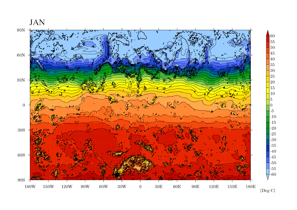
We investigated Arrakis using a climate model, a computer program similar to those used to give weather forecasts. We found the world that Herbert had created, well before climate models even existed, was remarkably accurate – and would be habitable, if not hospitable.

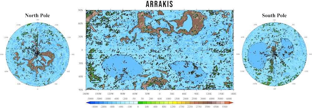
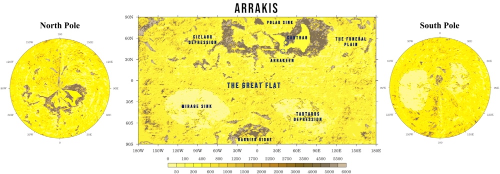
However, Arrakis wasn’t always a desert. In Dune lore, 91% of the planet was once covered by oceans, until some ancient catastrophe led to its desertification. What water remained was further removed by sand trout, an invasive species brought to Arrakis. These proliferated and carried liquid into cavities deep underground, leading to the planet becoming more and more arid.

To see what a large ocean would mean for the planet’s climate and habitability, we have now used the same climate model – putting in an ocean while changing no other factors.

When most of Arrakis is flooded, we calculate that the global average temperature would be reduced by 4°C. This is mostly because oceans add moisture to the atmosphere, which leads to more snow and certain types of cloud, both of which reflect the sun’s energy back into space. But it’s also because oceans on Earth and (we assume) on Arrakis emit “halogens” that cool the planet by depleting ozone, a potent greenhouse gas which Arrakis would have significantly more of than Earth.

Map of Arrakis
The authors gathered information from the books and the Dune Encyclopedia to build their original model. Then they added an ocean with 1,000 metres average depth.
Farnsworth et al, CC BY-SA

Unsurprisingly, the ocean world is a whopping 86 times wetter, as so much water evaporates from the oceans. This means plants can grow as water is no longer a finite resource, as it is on desert Arrakis.

A wetter world would be more stable

Oceans also reduce temperature extremes, as water heats and cools more slowly than land. (This is one reason Britain, surrounded by oceans, has relatively mild winters and summers, while places far inland tend to be hotter in summer and very cold in winter). The climate of an ocean planet is therefore more stable than a desert world.

In desert Arrakis, temperatures would reach 70°C or more, while in its ocean state, we put the highest recorded temperatures at about 45°C. That means the ocean Arrakis would be liveable even in summer. Forests and arable crops could grow outside of the (still cold and snowy) poles.

There is one downside, however. Tropical regions would be buffeted by large cyclones since the huge, warm oceans would contain lots of the energy and moisture required to drive hurricanes.

The search for habitable planets

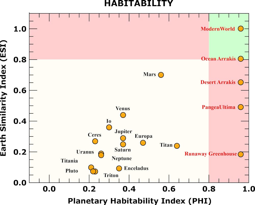
All this isn’t an entirely abstract exercise, as scientists searching for habitable “exoplanets” in distant galaxies are looking for these sorts of things too. At the moment, we can only detect such planets using huge telescopes in space to search for those that are similar to Earth in size, temperature, available energy, ability to host water, and other factors.

Scatter chart of planets comparing habitability and similarity to Earth.
Both desert and ocean Arrakis are considerably more habitable than any other planet we have discovered.
Farnsworth et al, CC BY-SA

We know that desert worlds are probably more common than Earth-like planets in the universe. Planets with potentially life-sustaining oceans will usually be found in the so-called “Goldilocks zone”: far enough from the Sun to avoid being too hot (so further away than boiling hot Venus), but close enough to avoid everything being frozen (so nearer than Jupiter’s icy moon Ganymede).

Research has found this habitable zone is particularly small for planets with large oceans. Their water is at risk of either completely freezing, therefore making the planet even colder, or of evaporating as part of a runaway greenhouse effect in which a layer of water vapour prevents heat from escaping and the planet gets hotter and hotter.

The habitable zone is therefore much larger for desert planets, since at the outer edge they will have less snow and ice cover and will absorb more of their sun’s heat, while at the inner edge there is less water vapour and so less risk of a runaway greenhouse effect.

It’s also important to note that, though distance from their local star can give a general average temperature for a planet, such an average can be misleading. For instance, both desert and ocean Arrakis have a habitable average temperature, but the day-to-day temperature extremes on the ocean planet are much more hospitable.

Currently, even the most powerful telescopes cannot sense temperatures at this detail. They also cannot see in detail how the continents are arranged on distant planets. This again could mean the averages are misleading. For instance, while the ocean Arrakis we modelled would be very habitable, most of the land is in the polar regions which are under snow year-round – so the actual amount of inhabitable land is much less.

Such considerations could be important in our own far-future, when the Earth is projected to form a supercontinent centred on the equator. That continent would make the planet far too hot for mammals and other life to survive, potentially leading to mass extinction.

If the most likely liveable planets in the universe are deserts, they may well be very extreme environments that require significant technological solutions and resources to enable life – desert worlds will probably not have an oxygen-rich atmosphere, for instance.

But that won’t stop humans from trying. For instance, Elon Musk and SpaceX have grand ambitions to create a colony on our closest desert world, Mars. But the many challenges they will face only emphasises how important our own Earth is as the cradle of civilisation – especially as ocean-rich worlds may not be as plentiful as we’d hope. If humans eventually colonise other worlds, they’re likely to have to deal with many of the same problems as the characters in Dune.The Conversation

————————

This blog is written by Cabot Institute for the Environment members Dr Alex Farnsworth, Senior Research Associate in Meteorology, and Sebastian Steinig, Research Associate in Paleoclimate Modelling, University of Bristol; and Michael Farnsworth, Research Lead Future Electrical Machines Manufacturing Hub, University of Sheffield. This article is republished from The Conversation under a Creative Commons license. Read the original article.

Prehistoric Planet: TV show asked us to explore what weather the dinosaurs lived through

Apple TV+, CC BY-NC-SA

When conjuring up images of when dinosaurs ruled the planet we often think of hot and humid landscapes in a world very different from our own. However, the new TV series Prehistoric Planet, narrated by Sir David Attenborough, shows dinosaurs living and indeed thriving in many types of environments, including colder regions where snowstorms, freezing fog and sea-ice were commonplace.

When the show’s producers first approached us to help understand the kinds of weather and environment that dinosaurs lived in before being wiped out around 66 million years ago, it prompted us to tackle a problem that has existed in palaeoclimate modelling for decades. That was, when scientists like us used computers to simulate, or “model”, the climate of prehistoric Earth, the models tended to make the poles much colder than evidence from fossils and rocks suggested they had actually been.

For the TV series, not only have we improved our models, but we have run the computer programmes for longer than anybody else has ever done to get the models as close to ancient “reality” as possible.

Prehistoric Planet depicts CGI dinosaurs based on the latest research.
AppleTV+, CC BY-NC-SA

The producers, the BBC’s Natural History Unit, needed to know about the weather so they could film “real world” locations similar to those that existed in the past where dinosaurs lived. But most of what we know about the climate that long ago comes from indirect “proxy” evidence, such as leaf fossils and traces of certain chemicals in rocks, which can only reconstruct the average climate over decades or centuries. This is where the narrative of a much hotter and more humid Cretaceous world comes from.

This narrative isn’t exactly wrong, but it doesn’t tell the whole story since weather and climate behave differently. For instance, even in today’s warming world a place like Texas, largely hot and humid, recently experienced widespread snowfall. Geologists a million years from now will spot the sudden global warming – but not the freak snowstorm. Nonetheless, modelling the the prehistoric equivalent of these snowstorms is important since we know warmer worlds will experience greater weather extremes. And these extremes will have largely determined which regions were completely inhospitable to dinosaurs.

Surface wind speed and precipitation through a typical year 69m years ago. An index of 1 means no visibility beyond 10 metres.

How do we know what the weather was like?

Unfortunately, although fossils give us many clues as to past climate, most cannot directly tell us what the weather was on a day to day basis.

So, for a given place on Earth, how do we know what the weather was on, say, May 27 some 66 million years ago? To do this we need to employ a computer simulation of the climate, similar to the ones used to look at future climate change today. These models are based on fundamental physical and biological processes which remain constant with time. It is therefore possible to adjust them for ancient worlds, even if we don’t know precise details like where or how high the mountains were, or exactly how much carbon dioxide was in the atmosphere.

We can then check these models using some of the ancient climate proxies, such as fossilised leaves, coral or rocks which contain traces of what conditions were like at the time. If our model matches up with the proxies – and it did – then we can be confident it is simulating typical weather at the time.

So what did we learn from modelling the climate of 66m years ago?

Our model found there would have been intense blizzards in Antarctica, for instance, “category six” hurricanes (something we are likely to see in our lifetimes) buffeting the mid and low latitudes and extensive, ever present, fog banks creating murky winters under polar cloud caps.

In a warmer world the water cycle is intensified over the poles. This meant more water in the air, and large parts of the planet would have been very foggy almost all the time (Source: modelling work by the authors)

This doesn’t immediately sound like a dinosaur-friendly environment. However, the old misconception that dinosaurs were cold blooded, thus requiring a warm climate for survival has for the most part already been dismissed. The new paradigm is that dinosaurs were warm blooded, and could to some extent regulate their internal temperature, like mammals do today.

This would be essential to survive large swings in temperature, driven by varied weather patterns, particularly in the polar regions. Our modelling therefore backs up recent fossil discoveries which show that some dinosaur species were cold-adapted, could see in low light conditions (useful in those huge fog banks), and thrived year-round near the poles.

Dinosaur in snow
Pachyrhinosaurus surviving and thriving.
AppleTV+, CC BY-NC-SA

The Prehistoric Planet scenes with the chilly Pachyrhinosaurus were set in Alaska, and demonstrate why the show wanted check its accuracy with climate models. We have an idea what the conditions would have been like there 66m years ago thanks to detailed fossils of plants, dinosaurs and other animals, yet the old models would have predicted intensely-cold and lifeless tundra.

Our model instead matches up with the fossil evidence, and predicts forests right up to the margins of the Arctic Ocean at 82°N – much further north than any trees today. In the summer, dinosaur food would have been abundant, but in the long dark winters it would have been more difficult to find, particularly as both fossils and modelling suggests it was so foggy.

Dinosaurs survived for a remarkable 165 million years. Tyrannosaurus Rex lived much closer to present day humans than it did to Stegosauruses, for instance. They managed to survive so long because they were resilient and adaptable to changeable environmental conditions, much like mammals are today. Our work for Prehistoric Planet shows that they were able to survive through greater extremes in temperature, stormier weather, and more extreme droughts than humans have experienced – so far.The Conversation

————————–

This blog is written by Cabot Institute for the Environment members Dr Alex Farnsworth, Senior Research Associate in Meteorology, and Paul Valdes, Professor of Physical Geography, University of Bristol; and Robert Spicer, Emeritus Professor of Earth Sciences, The Open University

This article is republished from The Conversation under a Creative Commons license. Read the original article.

Dune: how high could giant sand dunes actually grow on Arrakis?

Frank Herbert first published his science-fiction epic Dune back in 1965, though its origins lay in a chance encounter eight years previously when as a journalist he was tasked to report on a dune stabilisation programme in the US state of Oregon. Ultimately, this set the wheels in motion for the recent film adaptation.

The large and inhospitable sand dunes of the desert planet Arrakis are, of course, very prominent in both the books and film, not least because of the terrifying gigantic sandworms that hunt any movement on the surface. But just how high would sand dunes be on a realistic version of this world?

Before the movie was released, we took a scientific climate model and used it to simulate the climate of Arrakis. We now want to use insights from this same model to focus on the dunes themselves.

Sand dunes are the product of thousands or even tens of thousands of years of erosion of the underlying or surrounding geology. On a simple level, they are formed by sand being blown along the path of the prevailing wind until it meets an obstruction, at which point the sand will settle in front of it.

There is certainly no shortage of wind on Arrakis. Our simulation showed that wind would routinely exceed the minimum speed required to blow sand grains into the air, and there are even some regions where speeds regularly reach 162 km/h during the year. That’s well over hurricane force.

Diagram of sand dune formation
How sand dunes are formed. David Tarailo / US National Park Service / Geological Society of America

Sand dunes in the book are said to be on average around 100 metres high. However, this isn’t based on actual science, more likely it’s what Herbert knew from his time in Oregon as well as the world we live in. But we can use our climate model to predict what the general (and maximum) attainable height might suggest.

Where the wind blows

The size and distance between giant dunes are determined not simply by the type of sand or underlying rock, but by the lowest 2km or so of the atmosphere that interacts with the land surface. This level, also known as the planetary boundary layer, is where most of the weather we can see occurs. Above this, a thin “inversion layer” separates the weather below from the more stable higher-altitude part of the atmosphere.

The growth of sand dunes and theoretical height is determined by the depth of this boundary layer where the wind blows. Sand dunes stabilise above the wind at the altitude of the inversion layer. The height of the boundary layer – usually somewhere between 100 metres to 2,000 metres – can vary through the night as well as the year. When it is cooler, it is shallower. When there is a strong wind or lots of rising warm air, it is deeper.

Arrakis would be much hotter than Earth, which means more rising air and a boundary layer two to three times as high over land compared with ours. Our climate model simulation, therefore, predicts dunes on Arrakis would be as high as 250m, particularly in the tropics and mid-latitudes. That’s about three times the height of the Big Ben clock tower in London. Most regions would have a more modest average height of between 25m and 75m. As the boundary layer is generally higher everywhere on Arrakis the average dune height is in general twice that of Earths.

map with shaded areas
Predicted sand dune height (in metres) on Arrakis. Farnsworth et alAuthor provided

We were also able to simulate the space between dunes, which can also be determined by the height of the boundary layer. Spacing is highest in the tropics, a little over 2km between the crest of one giant sand dune to the next. However, in general, sand dunes have a spacing of around 0.5 to 1km crest to crest. Still plenty of room for a sandworm to wiggle through. Scientists looking at Saturn’s moon Titan have run this same process in reverse, using the space between dunes – easy to measure with satellite images – to estimate a boundary layer of up to 3km.

As nothing can grow on Arrakis to stabilise these sand dunes they will always be in a state of constant drift across the planet. Some large dunes on Earth can move about 5m a year. Smaller dunes can move even faster – about 20m a year.

A visualisation of the authors’ climate model of Arrakis. Source: climatearchive.org/dune.

Mountain-sized dunes?

Our simulation can only give the general height that most sand dunes would reach, and there would be exceptions to the rule. For instance, the largest known sand dune on Earth today is the Duna Federico Kirbus in Argentina, a staggering 1,234m in height. Its size shows that local factors, such as vegetation, surrounding hills or the type of local sand, can play an important role.

Given Arrakis is hotter than Earth, has a higher boundary layer and has more sand and stronger winds, it’s possible a truly mammoth dune the size of a small mountain may form somewhere – it’s just impossible for a climate model to say exactly where.

Scientists have recently revealed that as the world warms the planetary boundary layer is increasing by around 53 metres a decade. So we may well see even bigger record-breaking sand dunes as the lower atmosphere continues to warm – even if Earth will not end up like Arrakis.The Conversation

—————————–

This blog is written by Caboteers Dr Alex Farnsworth, Senior Research Associate in Meteorology, University of Bristol and Dr Sebastian Steinig, Research Associate in Paleoclimate Modelling, University of Bristol and Dr Michael Farnsworth, Research Lead Future Electrical Machines Manufacturing Hub, University of Sheffield,

This article is republished from The Conversation under a Creative Commons license. Read the original article.

Dune: we simulated the desert planet of Arrakis to see if humans could survive there

Dune, the epic series of sci-fi books by Frank Herbert, now turned into a movie of the same name, is set in the far future on the desert planet of Arrakis. Herbert outlined a richly-detailed world that, at first glance, seems so real we could imagine ourselves within it.

However, if such a world did exist, what would it actually be like?

We are scientists with specific expertise in climate modelling, so we simulated the climate of Arrakis to find out. We wanted to know if the physics and environment of such a world would stack up against a real climate model.

Here’s a visualisation of our climate model of Arrakis:

You can zoom in on particular features and highlight things like temperature or wind speed at our website Climate Archive.

When we were done, we were very pleased to discover that Herbert had envisioned an environment that for the most part meets expectations. We might need to occasionally suspend disbelief, but much of Arrakis itself would indeed be habitable, albeit inhospitable.

How do you build a fantasy world like Arrakis?

We started with a climate model commonly used to predict weather and climate here on Earth. To use these sorts of models you have to decide on the physical laws (well-known in the case of planet Earth) and then input data on everything from the shape of mountains to the strength of the sun or the makeup of the atmosphere. The model can then simulate the climate and tell you roughly what the weather might be like.

We decided to keep the same fundamental physical laws that govern weather and climate here on Earth. If our model presented something completely strange and exotic, this could suggest those laws were different on Arrakis, or Frank Herbert’s fantastical vision of Arrakis was just that, fantasy.

Height map (in metres) of Arrakis.
Farnsworth et al, Author provided

We then needed to tell the climate model certain things about Arrakis, based on the detailed information found in the main novels and the accompanying Dune Encyclopedia. These included the planet’s topography and its orbit, which was was essentially circular, akin to the Earth today. The shape of an orbit can really impact the climate: see the long and irregular winters in Game of Thrones.

Finally, we told the model what the atmosphere was made of. For the most part it is quite similar to that of the Earth today, although with less carbon dioxide (350 parts per million as opposed to our 417 ppm). The biggest difference is the ozone concentration. On Earth, there is very little ozone in the lower atmosphere, only around 0.000001%. On Arrakis it is 0.5%. Ozone is important as it is around 65 times more effective at warming the atmosphere than CO₂ over a 20-year period.

Having fed in all the necessary data, we then sat back and waited. Complex models like this take time to run, in this case more than three weeks. We needed a huge supercomputer to be able to crunch the hundreds of thousands of calculations required to simulate Arrakis. However, what we found was worth the wait.

Arrakis’s climate is basically plausible

The books and film describe a planet with unforgiving sun and desolate wastelands of sand and rock. However, as you move closer to the polar regions towards the cities of Arrakeen and Carthag, the climate in the book begins to change into something that might be inferred as more hospitable.

Yet our model tells a different story. In our model of Arrakis, the warmest months in the tropics hit around 45°C, whereas in the coldest months they do not drop below 15°C. Similar to that of Earth. The most extreme temperatures would actually occur in the mid-latitudes and polar regions. Here summer can be as hot as 70°C on the sand (also suggested in the book). Winters are just as extreme, as low as -40°C in the mid-latitudes and down to -75°C in the poles.

This is counter intuitive as the equatorial region receives more energy from the sun. However, in the model the polar regions of Arrakis have significantly more atmospheric moisture and high cloud cover which acts to warm the climate since water vapour is a greenhouse gas.

gif of temperatures
Monthly temperatures on Arrakis, according to the model. Both poles have very cold winters and very hot summers.
Author provided

The book says that there is no rain on Arrakis. However, our model does suggest that very small amounts of rainfall would occur, confined to just the higher latitudes in the summer and autumn, and only on mountains and plateaus. There would be some clouds in the tropics as well as polar latitudes, varying from season to season.

The book also mentions that polar ice caps exist, at least in the northern hemisphere, and have for a long time. But this is where the books perhaps differ the most from our model, which suggests summer temperatures would melt any polar ice, and there would be no snowfall to replenish the ice caps in winter.

Hot but habitable

Could humans survive on such a desert planet? First, we must make an assumption that the human-like people in the book and film share similar thermal tolerances to humans today. If that’s the case then, contrary to the book and film, it seems the tropics would be the most habitable area. As there is so little humidity there, survivable wet-bulb temperatures – a measure of “habitability” that combines temperature and humidity – are never exceeded.

The mid-latitudes, where most people on Arrakis live, are actually the most dangerous in terms of heat. In the lowlands, monthly average temperatures are often above 50-60°C, with maximum daily temperatures even higher. Such temperatures are deadly for humans.

Four people in black rubbery suits in desert
Stillsuit models, autumn 10191 collection.
Chiabella James / Warner Bros

We do know that all humanoid life on Arrakis outside of habitable places must wear “stillsuits”, designed to keep the wearer cool and reclaim body moisture from sweating, urination and breathing to provide drinkable water. This is important as stated in the book that there is no rainfall on Arrakis, no standing bodies of open water and little atmospheric moisture that can be reclaimed.

The planet also gets very cold outside of the tropics, with winter temperatures that would also be uninhabitable without technology. Cities like Arrakeen and Carthag would suffer from both heat and cold stress, like a more extreme version of parts of Siberia on Earth which can have both uncomfortably hot summers and brutally cold winters.

It’s important to remember that Herbert wrote the first Dune novel way back in 1965. This was two years before recent Nobel-winner Syukuro Manabe published his seminal first climate model, and Herbert did not have the advantage of modern supercomputers, or indeed any computer. Given that, the world he created looks remarkably consistent six decades on.


The authors modified a well-used climate model for exoplanet research and applied it to the planet in Dune. The work was carried out in their spare time and is intended as an appropriate outreach piece to demonstrate how climate scientists use mathematical models to better understand our world and exoplanets. It will feed into future academic outputs on desert worlds and exoplanets.The Conversation

This blog is written by Cabot Institute for the Environment members, Dr Alex Farnsworth, Senior Research Associate in Meteorology and Dr Sebastian Steinig, Research Associate in Paleoclimate Modelling, University of Bristol; and Michael Farnsworth, Research Lead Future Electrical Machines Manufacturing Hub, University of Sheffield.

This article is republished from The Conversation under a Creative Commons license. Read the original article.

The East Asian monsoon is many millions of years older than we thought

Sub-tropical rainforest in China. Image credit: UMBRELLA project

The East Asian monsoon covers much of the largest continent on Earth leading to rain in the summer in Japan, the Koreas and lots of China. Ultimately, more than 1.5 billion people depend on the water it provides for agriculture, industry and hydroelectric power.

Understanding the monsoon is essential. That is why colleagues and I recently reconstructed its behaviour throughout its 145m-year history, in order to better understand how it acts in response to changes in geography or the wider climate in the very long term, and what that might mean for the future.

Our study, published in the journal Science Advances indicates that the East Asian monsoon is much older and more varied than previously thought. Until quite recently the general consensus was that the monsoon came into being around 23m years ago, some time after the Tibetan Plateau was formed.

However, we show that it has been ever present for at least the past 145m years (except during the Late Cretaceous: the era of T. Rex), regardless of whether there was a Tibetan Plateau or how much CO₂ was in the atmosphere.

What is a monsoon?

At its most simple level a monsoon is a highly seasonal distribution in precipitation leading to a distinct “wet” and “dry” seasons – the word even derives from the Arabic “mausim”, translated as “season”.

The East Asian monsoon is a “sea breeze monsoon”, the most common type. They form because land and sea heat up at different rates, so high pressure forms over the sea and low pressure over land which results in wind blowing onshore in the summer.


It’s the world’s largest, highest plateau.
Rashevskyi Viacheslav / shutterstock

Although The Tibetan Plateau is not strictly needed to form the East Asian monsoon it can serve to enhance it. At 5km or more above sea level, the plateau simply sits much higher in the atmosphere and thus the air above it is heated much more than the same air would be at a lower elevation (consider the ground temperature in Tibet compared to the freezing air 5km above your head). As that Tibetan air is warmer than the surrounding cold air it rises and acts as a heat “pump”, sucking more air in to replace it and enhancing the monsoon circulation.

Changes over the (millions of) years

We found the intensity of the monsoon has varied significantly over the past 145m years. At first, it was around 30% weaker than today. Then, during the Late Cretaceous 100-66m years ago, a huge inland sea covered much of North America and weakened the Pacific trade winds. This caused East Asia to become very arid due to the monsoon disappearing.

However, rainfall patterns changed substantially after the Indian tectonic plate collided into the Asian continent around 50m years ago, forming the Himalayas and the Tibetan Plateau. As the land rose up, so did the strength of the monsoon. Our results suggest that 5-10m years ago there were “super-monsoons” with rainfall 30% stronger than today.

But how can we be sure that such changes were caused by geography, and not elevated carbon dioxide concentrations? To test this, we again modelled the climate for all different time periods (roughly every 4m years) and increased or reduced the amount of CO₂ in the atmosphere to see what effect this had on the monsoon. In general, irrespective of time period chosen, the monsoon showed little sensitivity (-1% to +13%) to changes in CO₂ compared to the impact of changes in regional geography.

Climate models are working

The monsoon in East Asia is mainly a result of its favourable geographic position and regional topography – though our work shows that CO₂ concentrations do have an impact, they are secondary to tectonics.

The past can help us better understand how the monsoon will behave as the climate changes – but its not a perfect analogue. Although rainfall increased almost every time CO₂ doubled in the past, each of these periods was unique and dependent on the specific geography at the time.

The reassuring thing is that climate models are showing agreement with geological data through the past. That means we have greater confidence that climate models are able to accurately predict how the monsoon will respond over the next century as humans continue to emit more CO₂ into the atmosphere.The Conversation

—————————–
This blog was written by Cabot Institute member Dr Alex Farnsworth, Postdoctoral Research Associate in meteorology at the University of Bristol. This article is republished from The Conversation under a Creative Commons license. Read the original article.

Alex Farnsworth

The last time Earth was this hot hippos lived in Britain (that’s 130,000 years ago)

Image taken from Wikimedia Commons. Credit Paul Maritz.

It’s official: 2015 was the warmest year on record. But those global temperature records only date back to 1850 and become increasingly uncertain the further back you go. Beyond then, we’re reliant on signs left behind in tree rings, ice cores or rocks. So when was the Earth last warmer than the present?

The Medieval Warm Period is often cited as the answer. This spell, beginning in roughly 950AD and lasting for three centuries, saw major changes to population centres across the globe. This included the collapse of the Tiwanaku civilisation in South America due to increased aridity, and the colonisation of Greenland by the Vikings.

But that doesn’t tell the whole story. Yes, some regions were warmer than in recent years, but others were substantially colder. Across the globe, averaged temperatures then were in fact cooler than today.

To reach a point when the Earth was significantly warmer than today we’d need to go back 130,000 years, to a time known as the Eemian.

For about 1.8m years the planet had fluctuated between a series of ice ages and warmer periods known as “interglacials”. The Eemian, which lasted around 15,000 years, was the most recent of these interglacials (before the one we’re currently in).

Although global annual average temperatures were approximately 1 to 2˚C warmer than preindustrial levels, high latitude regions were several degrees warmer still. This meant ice caps melted, Greenland’s ice sheet was reduced and the West Antarctic ice sheet may have collapsed. The sea level was at least 6m higher than today.

Across Asia and North America forests extended much further north than today and straight-tusked elephants (now extinct) and hippopotamuses were living as far north as the British Isles.

How do we know all this? Well, scientists can estimate the temperature changes at this time by looking at chemicals found in ice cores and marine sediment cores and studying pollen buried in layers deep underground. Certain isotopes of oxygen and hydrogen in ice cores can determine the temperature in the past while pollen tells us which plant species were present and therefore gives us an indication of climatic conditions suitable for that species.

We know from air bubbles in ice cores drilled on Antarctica that greenhouse gas concentrations in the Eemian were not dissimilar to preindustrial levels. However orbital conditions were very different – essentially there were much larger latitudinal and seasonal variations in the amount of solar energy received by the Earth.

So although the Eemian was warmer than today the driving mechanism for this warmth was fundamentally different to present-day climate change, which is down to greenhouses gases. To find a warm period caused predominantly by conditions more similar to today, we need to go even further back in time.


The past 540 million years. Note the Eemian spike and the Miocene Optimum.
Glen Fergus / wiki, CC BY-SA

As climate scientists, we’re particularly interested in the Miocene (around 23 to 5.3 million years ago), and in particular a spell known as the Miocene-Climate Optimum (11-17 million years ago). Around this time CO2 values (350-400ppm) were similar to today and it therefore potentially serves as an appropriate analogue for the future.

During the Optimum, those carbon dioxide concentrations were the predominant driver of climate change. Global average temperatures were 2 to 4˚C warmer than preindustrial values, sea level was around 20m higher and there was an expansion of tropical vegetation.

However, during the later Miocene period CO2 declined to below preindustrial levels, but global temperatures remained significantly warmer. What kept things warm, if not CO2? We still don’t know exactly – it may have been orbital shifts, the development of modern ocean circulation or even big geographical changes such as the Isthmus of Panama narrowing and eventually closing off – but it does mean direct comparison with the present day is problematic.

Currently orbital conditions are suitable to trigger the next glacial inception. We’re due another ice age. However, as pointed out in a recent study in Nature, there’s now so much carbon in the atmosphere the likelihood of this occurring is massively reduced over the next 100,000 years.
——————————
This blog is written by Cabot Institute members Emma Stone, Research Associate in Climatology, University of Bristol and Alex Farnsworth, Postdoctoral Researcher in Climatology, University of Bristol.

This article was originally published on The Conversation. Read the original article.

Weathermen of Westeros: Does the climate in Game of Thrones make sense?

The climate has been a persistent theme of Game of Thrones ever since Ned Stark (remember him?) told us “winter is coming” back at the start of season one. The Warden of the North was referring, of course, to the anticipated shift in Westerosi weather from a long summer to a brutal winter that can last for many years.

An unusual or changing climate is a big deal. George R R Martin’s world bears many similarities to Medieval Europe, where changes to the climate influenced social and economic developments through impacts on water resources, crop development and the potential for famine.

We’re interested in whether Westeros’s climate science adds up, given what we’ve learned about how these things work here on Earth.

It’s not easy to understand the mechanisms driving the climate system given we can’t climb into the Game of Thrones universe and take measurements ourselves. It’s hard enough to get an accurate picture of what’s driving the world’s climate even with many thousands of thermometers, buoys and satellite readings all plugging data into modern supercomputers – a few old maesters communicating by raven are bound to struggle.

The fundamental difference between our world and that of Westeros is of course the presence of seasons. Here on Earth, seasons are caused by the planet orbiting around the sun, which constantly bombards us with sunlight. However the amount of sunlight received is not the same throughout the year.


You won’t see this in Westeros. Rhcastilhos

If you imagine the Earth with a long pole through its centre (with the top and bottom of the pole essentially the North and South Pole) and then tilt that by 23.5 degrees, the amount of sunlight received in the Northern and Southern Hemispheres will change throughout the year as the Earth orbits the Sun.

Clearly the unnamed planet on which Game of Thrones is set is missing this axis tilt – or some other crucial part of Earth’s climate system.

How longer seasons might work

The simplest explanation could be linked to spatial fluctuations in solar radiation (sunlight) received at the surface. A reduction in incoming solar radiation would mean more snow and ice likely remaining on the ground during the summer in Westeros’s far north. Compared to the more absorbent soil or rock, snow reflects more of the Sun’s energy back out to space where in effect it cannot warm the Earth‘s surface. So more snow leads to a cooler planet, which means more snow cover on previously snow-free regions, and so on. This process is known as the snow albedo feedback.

The collapse of large ice sheets north of the Wall could also rapidly destabilise ocean circulation, reducing northward heat transport and leading to the encroachment of snow and ice southwards towards King’s Landing.


What if all this ice suddenly melted? HBO

To descend into glacial conditions would require a large decrease in solar radiation received at certain locations on the Earth’s surface and likewise an increase would be needed to return to warmer conditions.

This is roughly what happened during the switches between “glacial” and “interglacial” (milder) conditions throughout the past million years on Earth. This is controlled primarily by different orbital configurations known as “Milankovitch cycles”, which affect the seasonality and location of sunlight received on Earth.

However, these cycles are on the order of 23,000 to 100,000 years, whereas Game of Thrones seemingly has much shorter cycles of a decade or less.

When winter came back

Around 12,900 years ago there was a much more abrupt climate shift, known as the Younger Dryas, when a spell of near-glacial conditions interrupted a period of gradual rewarming after the last ice age peaked 21,000 years ago. The sudden thawing at the end of this cold spell happened in a matter of decades – a blink of an eye in geological terms – and led to the warm, interglacial conditions we still have today.


A particularly long and brutal winter? Younger Dryas
cooling is visible in Greenland ice core records.
 NOAA

Various different theories have tried to explain why this spike occurred, including the sudden injection of freshwater into the North Atlantic from the outburst of North American glacial lakes, in response to the deglaciation, which destabilised ocean circulation by freshening the water and reducing ocean heat transport to the North Atlantic Ocean, cooling the regional climate.
Less likely explanations include shifts in the jet stream, volcanic eruptions blocking out the sun, or even an asteroid impact.

The shift from the Medieval Warm Period to the Little Ice Age that began around 1300 AD represents a more recent, and more subtle, example of a “quick” climate change. Although the overall temperature change wasn’t too severe – a Northern Hemisphere decrease of around 1˚C compared with today – it was enough to cause much harsher winters in Northern Europe.
None of these events indicate the abrupt transitions from long summers to long winters as described in Game of Thrones – and they still all happen on a much longer timescale than a Westeros winter. However they do demonstrate how extreme climate shifts are possible even on geologically short timescales.

Regardless of the causes of the long and erratic seasons, winter in Westeros won’t be much fun. It may even make the struggle for the Iron Throne between the various factions seem irrelevant.
Indeed the House of Stark’s motto: “winter is coming” may have a lesson for us here on Earth. Anthropogenic climate change is one of the biggest challenges facing humankind today and if left unmitigated the potential environmental impact on society may be far greater than any global recession. Stop worrying about the Iron Throne, everyone, winter is coming.
————————————–
The Conversation
This blog has been written by Cabot Institute members Alex Farnsworth, a Postdoctoral Research Assistant in Climatology at University of Bristol and Emma Stone, a Research Associate in Climate History at University of Bristol.

This article was originally published on The Conversation. Read the original article.