Do not make policy during the middle of a flood crisis

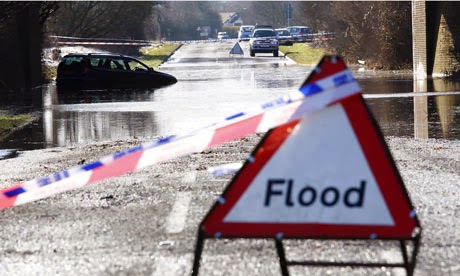
Across the country, we have seen our neighbours’ homes and farms devastated by the floods.  We understand their anger and frustration.  We understand their demands for swift action.

What they have been given is political gamesmanship.  Blame shifting from party to party, minister to minister, late responses, dramatic reversals of opinion.  It reached its well-publicised nadir this past weekend, with Eric Pickles’ appearance on the Andrew Marr show:

‘I apologise unreservedly and I’m really sorry that we took the advice; we thought we were dealing with experts.’

Throwing your own government experts to the wolves is not an apology.

This political vitriol, at least with respect to the Somerset Levels, all appears to come down to a relatively simple question – should we have been dredging?

This is not a simple question.  

It is an incredibly complex question, in the Somerset Levels and elsewhere, and this simplistic discussion does the people of those communities a great disservice.

Image by Juni

But more fundamentally, this is not the time to be deciding long-term flood mitigation strategy.  In times of disaster, you do disaster management.  Later, you learn the lessons from that disaster.  And finally, informed by evidence and motivated by what has happened, you set policy.  And that, to me, is the most frustrating aspect of the current political debate.  In an effort to out-manoeuvre one another, our leaders are making promises to enact policy for which the benefits appear dubious.

So, what are some of the issues, both for Somerset and in general?

First, the reason the rivers are flooding is primarily the exceptional rainfall – January was the wettest winter month in almost 250 years. This rain occurred after a fairly damp period, so that the soil moisture content was already high. However, these issues are exacerbated by how we have changed our floodplains, with both agricultural and urban development reducing water storage capacity.

Second, as the 2013-2014 flooding crisis has illustrated, much of our nation is flood-prone; however, those floods come in a variety of forms and have a range of exacerbating causes – some have been due to coastal storm surges, some due to flash floods caused by rapid flow from poorly managed lands and some due to sustained rain and soil saturation. We have a wet and volatile climate, 11,073 miles of coastline and little geographical room to manoeuvre on our small island.  Our solutions have to consider all of these issues, and they must recognise that any change in a river catchment will affect our neighbours downstream.

Flooding on West Moor, Somerset Levels
Image by Nigel Mykura

Third, returning to the specific challenge of the Somerset Levels, it is unclear what benefit dredging will have. The Somerset Levels sit near sea level, such that the river to sea gradient is very shallow.  Thus, rivers will only drain during low tide even if they are dredged.  And widening the channels will actually allow more of the tide to enter. Some have argued that in the past, dredging was more common and flooding apparently less so.  However, this winter has seen far more rain and our land is being used in very different ways: the memories of three decades ago are not entirely relevant.

Fourth, where dredging is done, it is being made more costly and challenging by land use practices elsewhere in the catchment. The rivers are filling with sediment that has eroded from intensively farmed land in the headwaters of the catchments and from the levels themselves. Practices that have greatly accelerated erosion include: heavy machinery operations in wet fields; placement of gates at the bottom of hillslopes so that sediment eroded from the field is very efficiently transported to impermeable road surfaces, and thence to streams downslope; cultivation of arable crops on overly steep slopes (increasing the efficiency of sediment transport from land to stream); overwintering of livestock on steep slopes; and excessive stocking densities on land vulnerable to erosion.

Image by Nicholas Howden

Nutrient enrichment from livestock waste and artificial fertilisers (when used in excess of crop requirements) also contribute to the dredging problem.  The nutrient loading often exceeds the system’s recycling capacity, such that nutrients flow into ditches and waterways, stimulating growth of aquatic plants that can readily clog up the minor ditches and waterways. With less space to dissipate water within the network, it is forced into the main channel.  In other words, some of these floods are a subsidised cost of agriculture – and by extension the low costs we demand of our UK-produced food.

And finally, if we are going to consider long-term planning, we must consider climate change impacts. Flooding will become worse due to sea level rise, which has already risen by about 12cm in the last 100 years, with a further 11-16cm of sea level rise projected by 2030.   It is less clear how climate change will affect the intensity and frequency of these particularly intense rainfall events. Although almost all projections indicate that dry areas will become dryer and wet areas will become wetter, predictions for specific geographical regions are highly uncertain.  And our historical records are not long enough to unravel long-term trends in the frequency of uncommon but high impact weather events. This should not be reassuring – it is another major element of uncertainty in an already complex problem.

As challenging as these issues are, they are not intractable. The solutions will involve stronger planning control and scientifically informed planning decisions (including allowing some areas to flood), a reconsideration of some intensive farming practices, some dredging in key areas, some controlled flooding in others, and better disaster management strategy for when the inevitable flooding does occur.  But now is not the time to resolve such a complicated knot of complex issues.  It is certainly not the time to offer false promises or miracle cures.

Now is the time to help our neighbours in distress, listen to their stories, and remember them when the floodwaters recede.  And then we should let our experts get on with their jobs.

This blog is co-written by Professor Paul Bates, Professor Penny Johnes (Geographical Sciences), Professor Rich Pancost (Chemistry) and Professor Thorsten Wagener (Engineering), all of whom are senior members of the Cabot Institute at the University of Bristol.

This blog post was first published in the Guardian on 12/02/2014, titled Flood crisis: Dredging is a simplistic response to a complex problem.

If you have any media queries relating to this blog, please contact Paul Bates or Rich Pancost (contact details in links above).

Prof Paul Bates, Head of
Geographical Sciences
Prof Rich Pancost, Director of the
Cabot Institute


Will global food security be affected by climate change?

The Intergovernmental Panel on Climate Change (IPCC) has just released an important report outlining the evidence for past and future climate change. Unfortunately it confirms our fears; climate change is occurring at an unprecedented rate and humans have been the dominant cause since the 1950s. Atmospheric carbon dioxide (CO₂) has reached the highest level for the past 800,000 years, which has contributed to the increased temperatures and extreme weather we have already started to see.

As a plant scientist, I’m interested in the complicated effects that increased temperatures, carbon dioxide and changes in rainfall will have on global food security. Professor David Lobell and Dr Sharon Gourdji wrote about some of the possible effects of climate change on crop yield last year, summarised below alongside IPCC data.

Increased CO₂

Plants produce their food in a process called photosynthesis, which uses the energy of the sun to combine CO₂ and water into sugars (food) and oxygen (a rather useful waste product). The IPCC reports that we have already increased atmospheric CO₂ levels by 40% since pre-industrial times, which means it is at the highest concentration for almost a million years. Much of this has accumulated in the atmosphere (terrible for global warming) or been absorbed into the ocean (causing ocean acidification) however it may be good news for plants.

Lobell and Gourdji wrote that higher rates of photosynthesis are likely to increase growth rates and yields of many crop plants. Unfortunately, rapid growth can actually reduce the yields of grain crops like wheat, rice and maize. The plants mature too quickly and do not have enough time to move the carbohydrates that we eat into their grains. 

High temperatures

The IPCC predicts that by the end of the 21st century, temperatures will be 1.5C to 4.5C higher than they were at the start of it. There will be longer and more frequent heat waves and cold weather will become less common.

Extremely high temperatures can directly damage plants, however even a small increase in temperature can impact yields. High temperatures means plants can photosynthesise and grow more quickly, which can either improve or shrink yields depending on the crop species (see above). Lobell and Gourdji noted that milder spring and autumn seasons would extend the growing period for plants into previously frosty times of year allowing new growth periods to be exploited, although heat waves in the summer may be problematic.

 
Image credit: IPCC AR5 executive summary
 

Flooding and droughts

In the future, dry regions will become drier whilst rainy places will get wetter. The IPCC predicts that monsoon areas will expand and increase flooding, but droughts will become longer and more intense in other regions.

In flooded areas, waterlogged soils could prevent planting and damage those crops already established. Drought conditions mean that plants close the pores on the leaves (stomata) to prevent water loss, however this means that carbon dioxide cannot enter the leaves for photosynthesis and growth will stop. This may be partly counteracted by the increased carbon dioxide in the air, allowing plants to take in more CO₂ without fully opening their stomata, reducing further water loss and maintaining growth.

 
Image credit: IPCC AR5 executive summary
 

These factors (temperature, CO₂ levels and water availability) interact to complicate matters further. High carbon dioxide levels may mean plants need fewer stomata, which would reduce the amount of water they lose to the air. On the other hand, higher temperatures and/or increased rainfall may mean that crop diseases spread more quickly and reduce yields.

Overall Lobell and Gourdji state that climate change is unlikely to result in a net decline in global crop yields, although there will likely be regional losses that devastate local communities. They argue that climate change may prevent the increases in crop yields required to support the growing global population however.

The effect of climate change on global crop yields is extremely complex and difficult to predict, however floods, drought and extreme temperatures will mean that its impact on global food security (“when all people at all times have access to sufficient, safe, nutritious food to maintain a healthy and active life”) will almost certainly be devastating.

On the basis of the IPCC report and the predicted impact of climate change on all aspects of our planet, not just food security, it is critical that we act quickly to prevent temperature and CO₂ levels rising any further.  


This blog is written by Sarah Jose, Biological Sciences, University of Bristol

You can follow Sarah on Twitter @JoseSci

Sarah Jose

Brinkmanship, flood insurance and science

The “Statement of Principles” on flood insurance agreed by the UK Government and the Association of British Insurers as a temporary measure in the year 2000 is due to expire on 31st July 2013. At the heart of this document is an undertaking by insurers to continue to provide cover for domestic property and small business customers as long the Government continues to manage the risk adequately.

Specifically the agreement says that cover will be provided for properties built before 2009 either if the risk is low or there is a commitment by the Environment Agency to reduce it to low within 5 years. ‘Low’ risk is arbitrarily defined as a property having a less than 1.3% annual chance of flooding, of which there are believed to be ~200,000 in England and Wales. In other words properties need to be protected against the 1 in 75 year event.

Premiums can still vary with risk and the Statement makes no explicit provision for affordability, but the agreement does allow owners of some at risk properties to continue to obtain cover (and hence for buyers of these properties to obtain mortgages). An implicit assumption is that for properties built after 2009 the planning system has been operating effectively and has only allowed development in low risk zones.

Negotiations over a replacement were clearly going to the wire but today a Memorandum of Understanding was agreed between the ABI and the Government. This involves the setting up of a flood insurance pool known as ‘Flood Re’ for the ~200,000 ‘high risk’ properties. Premiums for the ‘high risk’ properties will be set based on council tax band. Flood Re will charge member firms an annual charge of £180 million which equates to a levy of £10.50 on annual household premiums.

This represents the estimated level of cross-subsidy that already exists between lower and high flood risk premiums. The scheme will be up and running by summer 2015 and in the meantime, ABI members will continue to meet their commitments to existing customers under the old Statement of Principles agreement.

Clearly the questions most commentators have fixated on are “who pays?” and “how much?”. However, as a flood scientist a far more interesting question is “how will we know?” and this applies as much to the existing Statement as to any new agreement. To put this another way: are we confident that we can determine to reasonable accuracy which properties are ‘at risk’? You might think this is typical academic hand wringing, but actually answering this question is, in my view, critical to running an effective flood insurance business.

For any given site the 1.3% annual chance flood will not have been observed and the Environment Agency and insurers use computer models that simulate flooding to calculate what such events look like. To use these you need to know how big the 1.3% annual probability flow is and to have a detailed 3D map of the terrain. The model then uses more or less complex variations on Newtonian physics to determine how this volume of water moves over the land surface.

At particular places such models can be great, but all predictions have error and because of uncertainties in both data and models this is certainly the case with flooding. How big can these errors be? Well, in a recent study we found the plausible range for the current 1% annual probability flow for the River Avon in Warwickshire to be between 310 and 425 m3s-1: enough to make a significant difference to the area predicted as inundated. Ok, this isn’t the 1.3% level exactly, but you get the idea. Models also get worse as you zoom out because to be computationally tractable at regional to national scales they have to simplify the representation of terrain and flow which introduces errors.

Irrespective of what the ABI and the Government do in the future, this situation doesn’t change. The question of how good national scale flood risk assessments need to be to confidently manage risk and set insurance premiums is still unanswered.

This blog is taken from WillisWire and written by Cabot Institute Director Professor Paul Bates, University of Bristol and Willis Research Network (WRN) Senior Academic. Edits by Tim Fewtrell, Chief Hydrologist at the WRN

Professor Paul Bates, Cabot Institute Director