Net Zero Oceanographic Capability: the future of marine research


Image credit: Eleanor Frajka-Williams, NOC.

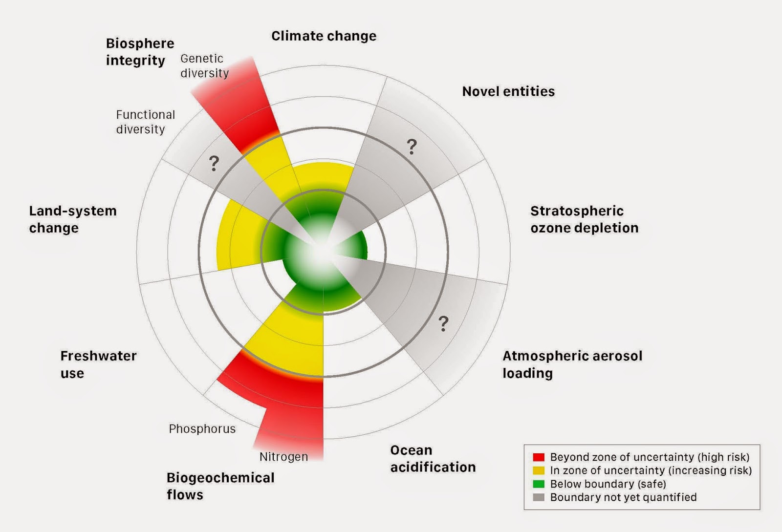
Our oceans are crucial in regulating global climate and are essential to life on Earth. The marine environment is being impacted severely by multiple and cumulative stressors, including pollution, ocean acidification, resource extraction, and climate change. Scientific understanding of marine systems today and in the future, and their sensitivity to these stressors, is essential if we are to manage our oceans, and achieve the United Nations Sustainable Development Goals (SDGs). However, these systems are complex – with a vast array of interacting physical, chemical, biological and sociological components – and operate on scales of microns to kilometres, and milliseconds to millennia. To address these challenges, modern marine science spans a wide range of multidisciplinary topics, including understanding the fundamental drivers of ocean circulation, ecosystem behaviour and its response to climate change, causes of and consequences of polar ice cap melt, and the impacts of ocean warming on sea level, weather and climate. Marine scientists investigate problems of societal relevance such as food security, hazards relating to sea level rise, storm surges and underwater volcanoes, and understanding the consequences of offshore development on the health of the ocean in the context of building a sustainable blue economy. With the start of the UN Decade of Ocean Science for Sustainable Development in 2021, there is a clear motivation not only for more research, but for sustainable approaches.

However, a key challenge facing all scientists in the near future is the absolute necessity to reduce and mitigate all carbon emissions, achieving ‘Net Zero’. Among many of the high-impact pledges made over recent months, UK Research and Innovation (UKRI) have promised to achieve Net Zero by 2040. UKRI is the umbrella organisation encompassing all of the UK Research Councils including the Natural Environment Research Council, which funds the National Oceanography Centre and British Antarctic Survey to operate the large-scale UK marine research infrastructure.

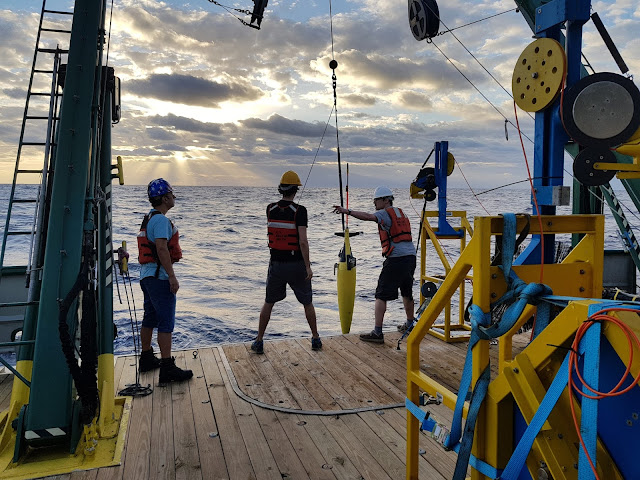
Whilst marine science is intrinsically linked to Net Zero objectives since the ocean is a major sink of anthropogenic carbon and excess heat, the carrying out marine research itself contributes to the problem in question: ocean-going research vessels use considerable amounts of fossil fuels. Ship-based observations allow scientists to address global challenges, to support ocean observing networks, make measurements not possible via satellite, or in remote and extreme environments. Such observations are essential to establish a thorough picture of how the ocean is changing, and the underlying processes behind the complex interweaving of physics, chemistry, biology and geology within marine systems, but can only continue into the future if the carbon footprint of sea-going research is cut dramatically.

Image credit: Eleanor Frajka-Williams, NOC.


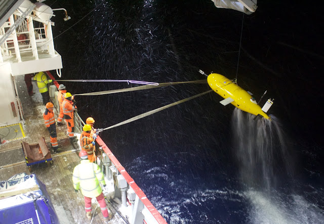
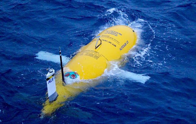
The Net Zero Oceanographic Capability (NZOC) scoping review, led by the National Oceanography Centre but supported by researchers from around the UK, is a groundbreaking project aimed at understanding the drivers and enablers of future oceanographic research in a Net Zero world. New technologies and infrastructure – together with multidisciplinary, international approaches, and collaborations with private and public sector stakeholders – are going to be increasingly important to advance understanding of the oceans and climate, while accomplishing Net Zero. The NZOC team are building a picture of a future research ecosystem that capitalises upon emerging technologies in shipping, marine autonomous systems (MAS) sensor technology and data science.  Ships will still be an essential linchpin of a new marine observing network, to gather critical information that may not be accessible using MAS, and to enable the maximum value to be extracted from datastreams collected during oceanographic expeditions.  The new Net Zero approaches have the potential to not just replace existing marine research capability with one less damaging to the environment, but also to expand and extend it, with new tools available more marine observing, new avenues of research opened up, and wider accessibility.  In order to achieve its potential, the development of new systems, and adaptation and improvement of existing methodologies, must be co-designed between technologists and scientists, including modellers and data scientists, as well as those engaged with sea-going observations.  Investment in an equitable, diverse and inclusive marine workforce must be considered from the beginning, with engagement in skills training for existing and future marine researchers so that scientists are primed to use the new approaches afforded by a Net Zero approach to their full potential.  All of these initiatives have to deliver on their promise in a co-ordinated way and in a short timeframe.  Many of them will rely upon global infrastructures and international systems that must similarly adapt at pace.

Image credit: Eleanor Frajka-Williams, NOC.

Environmental and climate scientists overwhelmingly and urgently support a move towards Net Zero. However, we cannot overstate the importance of getting the transition to Net Zero right. Whilst an ever-growing number of UK marine scientists are using MAS and low carbon options, NZOC also identified a number of case studies where achieving Net Zero will limit marine science – possibly permanently – if not addressed.  These include research areas where scientists need to drill into deep rock, or carry out intricate biological or geochemical experiments and measurements. Any transition to using new methods must be managed flexibly, requiring intersection between old and new technologies, due consideration to accessibility, and verification and validation by the wider scientific community.

Achieving Net Zero is one of the most important societal goals over the next decade. We can not only maintain but also build on marine science capability – essential for meeting Net Zero targets – with equitable and fair strategic planning, co-design of new approaches, and by taking advantage of new opportunities that arise from emerging technologies.

————————————
This blog is written by Cabot Institute member Dr Katharine Hendry is an Associate Professor in the School of Earth Sciences at the University of Bristol. With Contributions by Eleanor Frajka-Williams, National Oceanography Centre (NOC).
Dr Katharine Hendry


The future of sustainable ocean science

Westminster Central Hall

May 9th ushered in the 9th National Oceanography Centre (NOC) Association meeting, held among the crowds, statues, flags, and banners, at Central Hall in an unseasonably chilly and rainy Westminster. But it was the first such meeting where the University of Bristol was represented, and I was honoured to fly our own flag, for both University of Bristol and the Cabot Institute for the Environment.

NOC is – currently – a part of the Natural Environment Research Council (one of the UK Research Councils, under the umbrella of UKRI), but is undergoing a transformation in the very near future to an independent entity, and a charitable organisation in its own right aimed at the advancement of science. If you’ve heard of NOC, you’re likely aware of the NOC buildings in Southampton (and the sister institute in Liverpool). However, the NOC Association is a wider group of UK universities and research institutes with interests in marine science, and with a wider aim: to promote a two-way conversation between scientists and other stakeholders, from policy makers to the infrastructure organisations that facilitate – and build our national capability in – oceanographic research.

The meeting started with an introduction by the out-going chair of the NOC Association, Professor Peter Liss from the University of East Anglia, who is handing over the reins to Professor Gideon Henderson from Oxford University. The newly independent NOC Board will face the new challenges of changing scientific community, including the challenge of making the Association more visible and more diverse.

Professor Peter Liss, outgoing chair of the NOC Association,
giving the welcome talk

As well as the changes and challenges facing the whole scientific community, there are some exciting developments in the field of UK and international marine science in the next two years, which are likely to push the marine science agenda forward. In the UK, the Foreign Commonwealth Office International Ocean Strategy will be released in the next few months, and there is an imminent announcement of a new tranche of ecologically-linked UK Marine Protected Areas (MPAs) for consultation. On the international stage, a new Intergovernmental Panel on Climate Change special report on the Oceans and Cryosphere is due to be released in September; the Biodiversity Beyond National Jurisdiction (BBNJ) report on deep sea mining will be announced in the next few months; and the next United Nations Framework Convention on Climate Change (UNFCCC ) Conference of Parties (COP) climate change conference, scheduled for the end of this year in Chile, has been branded the “Blue COP”.

The afternoon was dedicated to a discussion of the upcoming UN Decade of Ocean Science for Sustainable Development, starting in 2021. With such a wealth of national and international agreements and announcements in next two years, the UN Decade will help to “galvanise and organise” the novel, scientific advice in the light of ever increasing and cumulative human impacts on the oceans.
Alan Evans, Head of the International and Strategic
Partnerships Office and a Marine Science Policy Adviser, giving a presentation
on the UN Decade of Ocean Science for Sustainable Development
The UN Decade is aligned strongly with the key global goals for sustainable development and has two overarching aims: to generate ocean science, and to generate policy and communication mechanisms and strategies. The emphasis is being placed on “science for solutions”, bringing in social scientists and building societal benefits: making the oceans cleaner, safer, healthier and – of course – all in a sustainable way.

Research and development priorities include mapping the seafloor; developing sustainable and workable ocean observing systems; understanding ecosystems; management and dissemination of open access data; multi-hazard warning systems (from tsunamis to harmful algal blooms); modelling the ocean as a compartment of the Earth system; and pushing for a robust education and policy strategy to improve “ocean literacy”.

Whilst these are exciting areas for development, the scheme is still in its very early stages, and there’s a lot to do in the next two years. As the discussion progressed, it was clear that there is a need for more “joined-up” thinking regarding international collaboration. There are so many international marine science-based organisations such that collaboration can be “messy” and needs to be more constructive: we need to be talking on behalf of each other. On a national level, there is a need to build a clear UK profile, with a clear strategy, that can be projected internationally. The NOC Association is a good place to start, and Bristol and the Cabot Institute for the Environment can play their parts.

Lastly, a decade is a long time. If the efforts are to be sustained throughout, and be sustainable beyond The Decade, we need to make sure that there is engagement with Early Career Researchers (ECRs) and mid-career researchers, as well as robust buy-in from all stakeholders. Whilst there are several national-scale organisations with fantastic programs to promote ECRs, such as the Climate Linked Atlantic Sector Science (CLASS) fellowship scheme and the Marine Alliance for Science and Technology for Scotland (MASTS) doctoral training program, this needs to be extended to ambitious international ECR networking schemes. Together with the future generation of researchers, we can use the momentum of the UN Decade make marine research sustainable, energised and diverse.

———————————

This blog is written by Dr Kate Hendry, a reader in Geochemistry in the University of Bristol School of Earth Sciences and a committee member for the Cabot Institute for the Environment Environmental Change Theme. She is the UoB/Cabot representative on the NOC Association, a member of the Marine Facilities Advisory Board (MFAB), and a co-chair of a regional Southern Ocean Observing System (SOOS) working group.

Participating and coaching at a risk communication ‘pressure cooker’ event

Anna Hicks (British Geological Survey) and BUFI Student (University of Bristol) Jim Whiteley reflect on their experiences as a coach and participant of a NERC-supported risk communication ‘pressure cooker’, held in Mexico City in May.

Jim’s experience….

When the email came around advertising “the Interdisciplinary Pressure Cooker on Risk Communication that will take place during the Global Facility for Disaster Reduction and Recovery (GFDRR; World Bank) Understanding Risk Forum in May 2018, Mexico City, Mexico” my thoughts went straight to the less studious aspects of the description:

‘Mexico City in May?’ Sounds great!
‘Interdisciplinary risk communication?’ Very à la mode! 
‘The World Bank?’ How prestigious! 
‘Pressure Cooker?’ Curious. Ah well, I thought, I’ll worry about that one later…

As a PhD student using geophysics to monitor landslides at risk of failure, communicating that risk to non-scientists isn’t something I am forced to think about too often. This is paradoxical, as the risk posed by these devastating natural hazards is the raison d’être for my research. As a geologist and geophysicist, I collect numerical data from soil and rocks, and try to work out what this tells us about how, or when, a landslide might move. Making sense of those numbers is difficult enough as it is (three and a half years’ worth of difficult to be precise) but the idea of having to take responsibility for, and explain how my research might actually benefit real people in the real world? Now that’s a daunting prospect to confront.

However, confront that prospect is exactly what I found myself doing at the Interdisciplinary Pressure Cooker on Risk Communication in May this year. The forty-odd group of attendees to the pressure cooker were divided in to teams; our team was made up of people working or studying in a staggeringly wide range of areas: overseas development in Africa, government policy in the US, town and city planning in Mexico and Argentina, disaster risk reduction (DRR) in Colombia, and of course, yours truly, the geophysicist looking at landslides in Yorkshire.

Interdisciplinary? Check.

One hour before the 4am deadline.

The possible issues to be discussed were as broad as overfishing, seasonal storms, population relocation and flooding. My fears were alleviated slightly, when I found that our team was going to be looking at hazards related to ground subsidence and cracking. Easy! I thought smugly. Rocks and cracks, the geologists’ proverbial bread and butter! We’ll have this wrapped up by lunchtime! But what was the task? Develop a risk communication strategy, and devise an effective approach to implementing this strategy, which should be aimed at a vulnerable target group living in the district of Iztapalapa in Mexico City, a district of 1.8 million people. Right.

Risk communication? Check.

It was around this time I realised that I glossed over the most imperative part of the email that had been sent around so many months before: ‘Pressure Cooker’. It meant exactly what it said on the tin; a high-pressure environment in which something, in this case a ‘risk communication strategy’ needed to be cooked-up quickly. Twenty-four hours quickly in fact. There would be a brief break circa 4am when our reports would be submitted, and then presentations were to be made to the judges at 9am the following morning. I checked the time. Ten past nine in the morning. The clock was ticking.

Pressure cooker? Very much check.

Anna’s experience….

What Jim failed to mention up front is it was a BIG DEAL to win a place in this event. 440 people from all over the world applied for one of 35 places. So, great job Jim! I was also really grateful to be invited to be a coach for one of the groups, having only just ‘graduated’ out of the age bracket to be a participant myself! And like Jim, I too had some early thoughts pre-pressure cooker, but mine were a mixture of excitement and apprehension in equal measures:

‘Mexico City in May?’ Here’s yet another opportunity to show up my lack of Spanish-speaking skills…
‘Interdisciplinary risk communication?’ I know how hard this is to do well…
‘The World Bank?’ This isn’t going to be your normal academic conference! 
‘Pressure Cooker?’ How on earth am I going to stay awake, let alone maintain good ‘coaching skills’?!

As an interdisciplinary researcher working mainly in risk communication and disaster risk reduction, I was extremely conscious of the challenges of generating risk communication products – and doing it in 24 hours? Whoa. There is a significant lack of evidence-based research about ‘what works’ in risk communication for DRR, and I knew from my own research that it was important to include the intended audience in the process of generating risk communication ‘products’. I need not have worried though. We had support from in-country experts that knew every inch of the context, so we felt confident we could make our process and product relevant and salient for the intended audience. This in part was also down to the good relationships we quickly formed in our team, crafted from patience, desire and ability to listen to each other, and for an unwavering enthusiasm for the task!

The morning after the night before.

So we worked through the day and night on our ‘product’ – a community based risk communication strategy aimed at women in Iztapalapa with the aim of fostering a community of practice through ‘train the trainer’ workshops and the integration of art and science to identify and monitor ground cracking in the area.

The following morning, after only a few hours’ sleep, the team delivered their presentation to fellow pressure-cooker participants, conference attendees, and importantly, representatives of the community groups and emergency management teams in the geographical areas in which our task was focused. The team did so well and presented their work with confidence, clarity and – bags of the one thing that got us through the whole pressure cooker – good humour.

It was such a pleasure to be part of this fantastic event and meet such inspiring people, but the icing on the cake was being awarded ‘Best Interdisciplinary Team’ at the awards ceremony that evening. ‘Ding’! Dinner served.

—————
This blog has been reposted with kind permission from James Whiteley.  View the original blog on BGS Geoblogy.   This blog was written by James Whiteley, a geophysicist and geologist at University of Bristol, hosted by British Geological Survey and Anna Hicks from the British Geologial Survey.

How to turn a volcano into a power station – with a little help from satellites

File 20171031 18735 1gapo0c.jpg?ixlib=rb 1.1
Erta Ale in eastern Ethiopia. mbrand85

Ethiopia tends to conjure images of sprawling dusty deserts, bustling streets in Addis Ababa or the precipitous cliffs of the Simien Mountains – possibly with a distance runner bounding along in the background. Yet the country is also one of the most volcanically active on Earth, thanks to Africa’s Great Rift Valley, which runs right through its heart.

Rifting is the geological process that rips tectonic plates apart, roughly at the speed your fingernails grow. In Ethiopia this has enabled magma to force its way to the surface, and there are over 60 known volcanoes. Many have undergone colossal eruptions in the past, leaving behind immense craters that pepper the rift floor. Some volcanoes are still active today. Visit them and you find bubbling mud ponds, hot springs and scores of steaming vents.

Steam rising at Aluto volcano, Ethiopia. William Hutchison

This steam has been used by locals for washing and bathing, but underlying this is a much bigger opportunity. The surface activity suggests extremely hot fluids deep below, perhaps up to 300°C–400°C. Drill down and it should be possible access this high temperature steam, which could drive large turbines and produce huge amounts of power. This matters greatly in a country where 77% of the population has no access to electricity, one of the lowest levels in Africa.

Geothermal power has recently become a serious proposition thanks to geophysical surveys suggesting that some volcanoes could yield a gigawatt of power. That’s the equivalent of several million solar panels or 500 wind turbines from each. The total untapped resource is estimated to be in the region of 10GW.

Converting this energy into power would build on the geothermal pilot project that began some 20 years ago at Aluto volcano in the lakes region 200km south of Addis Ababa. Its infrastructure is currently being upgraded to increase production tenfold, from 7MW to 70MW. In sum, geothermal looks like a fantastic low-carbon renewable solution for Ethiopia that could form the backbone of the power sector and help lift people out of poverty.


Scratching the surface

The major problem is that, unlike more developed geothermal economies like Iceland, very little is known about Ethiopia’s volcanoes. In almost all cases, we don’t even know when the last eruption took place – a vital question since erupting volcanoes and large-scale power generation will not make happy bedfellows.

In recent years, the UK’s Natural Environment Research Council (NERC) has been funding RiftVolc, a consortium of British and Ethiopian universities and geological surveys, to address some of these issues. This has focused on understanding the hazards and developing methods for exploring and monitoring the volcanoes so that they can be exploited safely and sustainably.

Teams of scientists have been out in the field for the past three years deploying monitoring equipment and making observations. Yet some of the most important breakthroughs have come through an entirely different route – through researchers analysing satellite images at their desks.

This has produced exciting findings at Aluto. Using a satellite radar technique, we discovered that the volcano’s surface is inflating and deflating. The best analogy is breathing – we found sharp “inhalations” inflating the surface over a few months, followed by gradual “exhalations” which cause slow subsidence over many years. We’re not exactly sure what is causing these ups and downs, but it is good evidence that magma, geothermal waters or gases are moving around in the depths some five km below the surface.

Taking the temperature

In our most recent paper, we used satellite thermal images to probe the emissions of Aluto’s steam vents in more detail. We found that the locations where gases were escaping often coincided with known fault lines and fractures on the volcano.

When we monitored the temperature of these vents over several years, we were surprised to find that most were quite stable. Only a few vents on the eastern margin showed measurable temperature changes. And crucially, this was not happening in synchronicity with Aluto’s ups and downs – we might have expected that surface temperatures would increase following a period of inflation, as hot fluids rise up from the belly of the volcano.

A productive geothermal well on Aluto. William Hutchison

It was only when we delved into the rainfall records that we came up with an explanation: the vents that show variations appear to be changing as a delayed response to rainfall on the higher ground of the rift margin. Our conclusion was that the vents nearer the centre of the volcano were not perturbed by rainfall and thus represent a better sample of the hottest waters in the geothermal reservoir. This obviously makes a difference when it comes to planning where to drill wells and build power stations on the volcano, but there’s a much wider significance.

This is one of the first times anyone has monitored a geothermal resource from space, and it demonstrates what can be achieved. Since the satellite data is freely available, it represents an inexpensive and risk-free way of assessing geothermal potential.

With similar volcanoes scattered across countries like Kenya, Tanzania and Uganda, the technique could allow us to discover and monitor new untapped geothermal resources in the Rift Valley as well as around the world. When you zoom back and look at the big picture, it is amazing what starts to come into view.
——————————-
This blog is written by William Hutchison, Research Fellow, University of St Andrews; Juliet Biggs, Reader in Earth Sciences and Cabot Institute member, University of Bristol, and Tamsin Mather, Professor of Earth Sciences, University of Oxford

This article was originally published on The Conversation. Read the original article.
——————————
Juliet Biggs is a member of the University of Bristol Cabot Institute.  She studies Continental Tectonics and Volcanic Deformation and has won numerous awards in her field.  Find out more about Juliet Biggs research.

Measuring greenhouse gases during India’s monsoon

NERC’s BAe-146 research aircraft at the Facility for Airborne Atmospheric Measurements (FAAM). Image credit: FAAM
This summer, researchers across the UK and India are teaming up to study the Indian monsoon as part of a £8 million observational campaign using the NERC research aircraftBAe-146

India receives 80% of its annual rainfall in three months – between June and September. There are large year-to-year differences in the strength of the monsoon, which is heavily impacted by drivers such as aerosols and large-scale weather patterns, and this has significant impact on the livelihoods of over a billion people. For example, due to the strong El Nino last year, the 2015 monsoon experienced a 14% lower precipitation than average with some regions of India facing up to 50% shortfall.  Forecasting the timing and strength of the monsoon is critical for the region and particularly for India’s farmers, who must manage water resources to avoid failing crops.


Roadside mural of the BAe-146 in Bangalore, India. Original artist unknown.  Image credit: Guy Gratton

The observational campaign, which is part of NERC’s Drivers of Variability in the South Asian Monsoon programme, is led jointly by UK researchers: Professor Hugh Coe (University of Manchester), Dr Andy Turner (University of Reading) and Dr Adrian Matthews (University of East Anglia) and Indian scientists from the Indian Space Research Organization and Indian Institute of Science.

Bristol PhD student Dan Say installing sample containers on the BAe- 146. Image credit: Angelina Wenger

To complement this project to study physical and chemical drivers of the monsoon, I am measuring greenhouse gas from the aircraft with PhD student Dan Say (School of Chemistry, University of Bristol). Dan is gaining valuable field experience by operating several instruments aboard the BAe-146 through the intense heat and rain of the Indian monsoon.

Two of the greenhouse gases that we are studying, methane and nitrous oxide, are primarily produced during the monsoon season from India’s intensive agriculture. Methane is emitted from rice paddies, in which flooded soils create prime conditions for “anaerobic” methane production. Nitrous oxide is also emitted from these flooded soils due the large quantity of fertilizers that are applied, again through anaerobic pathways. 


Rice fields near Bangalore, India. Image credit: Guy Gratton.

Our previous understanding of the large-scale emissions of these greenhouse gases from India’s agricultural soils has been limited and we aim to further our knowledge of what controls their production. In addition to the methane concentrations measured on the aircraft, with collaborators at the Royal Holloway, University of London’s isotope facility, we are also measuring the main isotope of methane (the 13-carbon isotope), which will provide us with a valuable tool for differentiating between agricultural and other sources of methane in the region. By combining this information with other measurements from the aircraft (for example, of moisture and of other atmospheric pollutants), we aim to gain new insights on how we may reduce these emissions in the future.

In addition, many synthetic “man-made” greenhouse gases are being measured for the first time in South Asia, giving us the first look at emissions from this region of some of the most potent warming agents. These include the suite of halocarbons such as hydrofluorocarbons (HFCs) and their predecessors the hydrochlorofluorocarbons (HCFCs) and chlorofluorocarbons (CFCs). These gases will be measured on the University of Bristol School of Chemistry’s ‘Medusa’ gaschromatography-mass spectrometer (GC-MS) facility run by Professor Simon O’Doherty.


Sample canisters for collecting air that will be measured on the School of Chemistry’s ‘Medusa’ GC-MS facility. Image credit: Angelina Wenger

————————————-

This blog is written by University of Bristol Cabot Institute member Dr Anita Ganesan, a NERC Research Fellow, School of Geographical Sciences, who looks at greenhouse gas emissions estimation.
Anita Ganesan

University of Bristol’s green heroes: Katherine Baldock

In the run up to the Bristol Post’s Green Capital Awards, we thought we’d highlight some of our key Green Heroes and Green Leaders at the University of Bristol.  As part of a four part blog series this week, we will be highlighting some of the key figures behind the scenes and in front of the limelight who are the green movers and shakers of our university.  There are many more Green Heroes across the University that we would like to celebrate. To find out more about who they are and what they are doing, please visit our Sustainability Stories website.
———————————————–

Katherine Baldock

Katherine is a NERC Knowledge Exchange Fellow in the School of Biological Sciences and at the Cabot Institute at the University of Bristol.

Katherine has come from a background in Biology, studying in Bristol as an undergraduate. Her subsequent passion for biology and ecology has drawn her to study at various institutions and work all over the world in places such as Costa Rica and Kenya.

Her academic work is focussed on the networks of interactions between plants and their pollinators, particularly in urban environments. Her research objectives aim to improve the value of UK urban areas for insect pollinators; research which hopes to positively impact insects that are essential for maintaining a functioning ecosystem and subsequently our food supplies. Her current role requires her to liaise with policymakers, practitioners and conservation charities to ensure an effective link between research and policy. Her work is essential to Bristol as well as cities across the UK and has resulted in government action, as she elaborates: “The government have published a National Pollinator Strategy and a partnership of organisations has created a local Greater Bristol Pollinator Strategy so that we can promote action for pollinators across the whole city”.

Her work is more than just a job, Katherine is passionate about the research she does and the effects it has on our cities as she explains: “If everyone plays a part and creates a little bit of habitat for bees and other pollinating insects in their own gardens, allotments or window boxes we could really make a difference. I’m passionate about preserving nature, not just for nature’s sake but also because it is incredibly important for our health and wellbeing and provides us with so many essential services – from crop pollination to carbon sequestration to water purification.”

———————————————

This blog is written by Cabot Institute member Keri McNamara, a PhD student in the School of Earth Sciences at the University of Bristol.

If you would like to nominate your Green Hero or Green Leader in the upcoming Bristol Post Green Capital Awards, please visit the official Green Capital Awards website.  Entries close on 18 September 2015.

To learn more about the University of Bristol’s activities during the Bristol 2015 European Green Capital year, please visit bristol.ac.uk/green-capital.

Fieldwork activities: A great opportunity to expose young scientists and engineers to novel technologies

Between 29 June and 7 July, three environmental monitoring stations have been installed in an organic farm approximately 15 km east of Swindon. The stations are part of the AMUSED project, funded by NERC and lead by me, Rafael Rosolem (Lecturer in Civil Engineering), with the ultimate goal being to identify key dominant processes that control changes in soil moisture and land-atmosphere interactions in the UK.

Each station is equipped with standard meteorological sensor as well as new technology for measuring soil moisture at spatial scales of approximately 600m diameter through cosmic-ray neutron interactions at approximately. The AMUSED network covers an area of approximately 1.7 square kilometers and will provide soil moisture estimates for hyper-resolution hydrometeorological modeling around the farm taking into account spatial scale heterogeneities not seen by satellite remote sensing products. The three sites are above chalk landscape and will improve our understanding of soil moisture and evaporation dynamics in such regions across a range of spatial scales.

Novel cosmic-ray sensor network will help estimate soil moisture at
hyper-resolution while accounting for differences in land cover and
soil characteristics. Source: Rafael Rosolem

An important aspect recognized in the AMUSED project is to expose young engineers and scientists to the novel cosmic-ray sensor technology. Our fieldwork was organized so that a small group of scientists and engineers carried out fieldwork and laboratory activities while learning more about environmental sensors.

The small group consisted of a post-doctoral researcher (Shams Rahman), a Civil Engineering PhD student (Joost Iwema), and a Civil Engineering undergraduate student (Juliana Koltermann da Silva) from the Universidade Federal do Rio Grande do Sul in Brazil. Shams Rahman interests include understanding groundwater-atmosphere coupling through numerical models. He is currently working under the AMUSED project. Joost Iwema is a second year PhD candidate in the Department of Civil Engineering. His background is in Soil Sciences, and he has been directly working with cosmic-ray sensors. Juliana Koltermann da Silva is a Brazilian Sciences Without Borders undergraduate student with interest in Geotechnics.

While in the field, the group had a chance to interact directly with cosmic-ray sensor developer, Darin Desilets, from Hydroinnova, asking questions and learning more about this new technology. Fieldwork activities were also supported by the Faculty of Engineering and the University of Bristol International Office.

Woodland site: Left to right: Juliana (undergraduate student), Joost (PhD candidate),
Shams (Post-Doctoral Research Assistant), and Rafael (Lecturer in Civil Engineering).
Source: Rafael Rosolem
The group had an opportunity to interact with Darin Desilets (Hydroinnova; left in
the photo) during fieldwork and laboratory activities to learn more about the
new cosmic-ray sensor technology. Source: Rafael Rosolem

The fieldwork also involved collection of a large number of soil samples for analysis (more than 100 samples within 200m radius for each site). Soil samples are currently being analyzed in order to calibrate not only the cosmic-ray sensors but also cross-calibrate additional soil moisture sensors available in the site.

We collect approximately 60 soil samples to a depth of 30cm during the field
campaign. Each profile is further subdivided into 6 x 5cm thickness layers,
which are then used for calibrating the cosmic-ray sensors and numerical
models used in the NERC AMUSED project. Source: Rafael Rosolem.

One of the aims of the AMUSED project is to engage in knowledge transfer to young scientists and engineers, with a distinct backgrounds and at different stages of their careers, to novel technologies for environmental monitoring while providing a good balance between fieldwork and laboratory activities as well as numerical modeling approaches.

——————————-
This blog is written by Cabot Institute member Rafael Rosolem (Lecturer in Civil Engineering).

Rafael Rosolem

Insights from the Natural Systems and Processes Poster Session

The Natural Systems and Processes Poster Session (NSPPS) is a University-wide poster session for postgraduate students within the Faculty of Science aimed at increasing inter-departmental connections within a relaxed and informal environment. This year’s event, which was hosted within the Great Hall of the Wills Memorial Building, was attended by ~90 PhD students from a wide variety of disciplines and hundreds more visitors came from across the University to view the posters. Most participants were interested in tackling the challenges of uncertain environmental change with an emphasis upon climate change, natural hazards and human impacts on the environment.

The Natural Systems and Processes Poster Session 2015 in the Great Hall
in the Wills Memorial Building (Image credit: D. Naafs)
Adam McAleer, a final year PhD student working in the Department of Earth Sciences, is interested in measuring the flux of greenhouse gases from restored peatlands within Exmoor National Park. The Exmoor Mires Project seeks to raise water levels via blocking of old agricultural drains in order to re-saturate the peatlands and recover its peat-forming biogeochemistry. This will potentially lead the mires to become carbon dioxide sinks and methane sources. As wetter plants were found to have a strong association to higher methane emissions, certain plant species have the potential to be used as a proxy for methane fluxes and restoration success. Mark Lunt, a third year PhD student working within the Atmospheric Chemistry Research Group, is interested in the fate of other greenhouse gases, such as hydrofluorocarbons (HFCs). Hydrofluorocarbons are organic compounds that contain fluorine and hydrogen atoms and are used as refrigerants, aerosol propellants, solvents, and fire retardants in the place of chloroflourocarbons (CFCs). Although HFCs do not harm the ozone layer, they can contribute to global warming. In developing countries, demand for HFCs are increasing rapidly; as a result, both the USA and China have agreed to begin work on phasing out hydroflourocarbons.

Felipe (left) discussing his research to staff and students  (Image credit: D. Naafs)
 
Catherine McIntyre (1st year) and John Pemberton (1st year), based within the Organic Geochemistry Unit, presented work from the NERC-funded DOMAINE project. This project aims to look at dissolved organic matter (DOM) in freshwater ecosystems and public water supplies and will focus upon the fate of carbon, nitrogen and phosphorus. Phosphorus, for example, is used to make fertilisers and can be incorporated into lakes and streams via terrestrial run-off. As phosphorus is a key limiting nutrient, it can also stimulate algal blooms and lead to eutrophication (i.e. oxygen starvation). Indeed, the global phosphorus cycle has already been highly perturbed, as shown below. As very little is known about organic phosphorus, the DOMAIN project will investigate this further using via high-resolution molecular techniques.

Four of the nine planetary boundaries  have now been crossed (Steffen et al., 2015; Science)
 
Other students are using the past to explore the future. Matt Carmichael, a final year PhD based within the School of Chemistry, is interested in understanding how the hydrological cycle varied during past warm climates. Of particular interest is the early Eocene (~48 to 56 million years ago), an interval characterised by high atmospheric carbon dioxide, high sea surface temperatures and the absence of continental ice sheets. However, the impact of these changes on the wider Earth system, especially those related to precipitation patterns, vegetation and biogeochemical cycles, remain poorly understood. This is achieved using climate models which can simulate changes in the atmosphere and the ocean during the Eocene. Future climatic change will also have a profound effect upon the hydrological cycle with the potential to make floods and droughts more extreme.

How the East Antarctic coastline might have looked during the early Eocene (Pross et al., 2012; Nature)

Collectively, the NSPPS highlights the wide variety of research undertaken with the Faculty of Science and is a great opportunity for PhD students to present their research in a relaxed setting.


————————–
This blog was written by Gordon Inglis (@climategordon) a final year PhD student within the School of Chemistry. Additional thanks to Adam McAleer, Matt Carmichael, Mark Lunt, Catherine McIntyre and John Pemberton whose work is highlighted here. 

Life on the ice: Fieldwork in Antarctica

From early November last year, I was lucky enough to spend over two months doing fieldwork on Pine Island Glacier, an ice stream in West Antarctica, which is currently the largest single contributor to sea level rise. I was part of a twelve person team that made up the second iSTAR traverse.

iSTAR is a collaborative scientific programme, funded by the Natural Environment Research Council (NERC) and co-ordinated by the British Antarctic Survey (BAS). It aims to improve our understanding of the stability of the West Antarctic Ice Sheet, which could potentially undergo rapid retreat in the coming centuries. It is divided into two halves – half the programme is ocean focused, looking at how relatively warm Circumpolar Deep Water intrusions onto the continental shelf interact with the ice shelves in the Amundsen Sea. The University of Bristol is involved in the second half of the programme, which is concerned with the ice sheet dynamics and mass balance, particularly the changes happening to Pine Island Glacier (PIG). In order to study these changes, two traverses of PIG have been made, over two consecutive seasons (2013-14 and 2014-15). The 800 km traverse, took in 22 sites across the ice stream and its tributaries, where various scientific techniques were used to determine the properties of the ice, glacier bed and firn layer (compacted snow).

During this season, despite some strong winds, we successfully completed all the science we set out to do, included seven seismic surveys, ten shallow ice cores, 22 neutron probe snow density profiles and ten phase-sensitive radar profiles. For me, as a PhD student, it was a great experience to work with senior scientists in the field, and to be involved in such a wide range of field techniques.

The scientific goals of the iSTAR traverse could not been achieved without the use of the traverse logistics, which involved using Pisten Bully snow tractors to tow the caboose (a converted container that acts as kitchen and living space), equipment and fuel from site to site. This is a new way of field operation for BAS and is likely to feature in many more scientific programmes in the future, given the success of the two iSTAR traverses. Of course, there are some old-school field scientists who joke that we are the Caravan Club of Antarctica, but I think they are just jealous – eating pancakes for breakfast in the caboose has to beat sitting in a pyramid tent eating rehydrated rations!

On the move! Image credit: Isabel Nias
Despite the perhaps more luxurious living conditions than the average field party, living in the deep field on the ice was not without its challenges. We were still sleeping in tents and my standard answer to the question, “but how did you wash?” has been, “I didn’t”. At the beginning of the field season we had temperatures as cold as -35°C (plus wind chill), which froze your breath inside your nostrils. However, I preferred the cold to the “warm” temperatures we had towards the end of the field season (it hit 0°C at one point!), which made our boots and gloves all damp. The work was also physically hard. Each seismic survey was 7 km long, and involved a team of us drilling 30 hot water drill holes, which were then loaded with explosives, and digging over 700 holes to place the geophone sensors in the snow. Although it was worth it for the end product: an idea of the type of bedrock PIG is flowing over.

Before I arrived, I had heard from Steph Cornford, who was on the first iSTAR traverse, that the weather had been exceptionally pleasant last year, with plenty of blue skies and low winds. So much so that they ate their Christmas dinner outside! This year, the weather was more like what you would expect from Antarctica – we certainly had our fair share of strong winds, which hindered progress at times, especially due to the sensitivity of the seismic work to wind speed. I got very good at estimating the wind speed based on how much my tent was shaking, or by looking at the Union Jack flying from the caboose!

Emma Smith and Alex Brisbourne (BAS) making their way to the
safety of the caboose on New Year’s Day. Image credit: Alex Taylor.
New Year on PIG was certainly one to remember. We spent the evening doing a pub quiz in the caboose and seeing in the New Year with a whisky and a poor rendition of Auld Lang Syne. By 1:30 am, however, the winds had picked up to 50 knots with gusts of up to 65 knots, creating extreme white out conditions from all the blowing snow. Many of us who were still up decided to sleep in the caboose that night. I’m glad I did because I doubt I would have slept at all in my tent (from the noise and the fear that the tent would be ripped from its pitch!). The strong winds persisted well into New Year’s Day, but we were able to assess the damage. Rather than blowing away, my tent was actually half buried by a huge drift. However, it could have been worse – James’ tent was destroyed and completely filled with snow! It took the whole of the next day to get camp cleared again – is “shovelling snow” a worthy thing to put on my CV?

Looking back, it is not working until 3 am to finish a seismic line that I remember. Rather, it is the people, as well as all the amazing experiences I had, which stick in my mind. It’s not every day that you co-pilot a plane across West Antarctica or bake a Christmas cake on 1800 m thick ice.

I would like to thank iSTAR, BAS and all the guys at the Rothera Research Station for such an awesome experience. The real work starts now – we have a lot of data to work on! Have a look on the iSTAR website for more blog posts written while we were in the field.
The second iSTAR traverse team at Christmas, complete with a ratchet strap Christmas tree. Image credit: Alex Taylor
——————————
Cabot Institute member Isabel Nias is a PhD student in the Bristol Glaciology Centre, School of Geographical Sciences at the University of Bristol.  Her PhD, which is funded through the NERC iSTAR programme, aims to use ice flow modelling to understand the sensitivity of the Amundsen Sea ice streams, and their potential impact on future sea level rise.
Isabel Nias